Tide gate failures: correcting Somerset drainage errors
Somerset County has very little elevation to spare. Only about 10% of the county sits above 20 feet, while 58% of its 329 square miles lies inside a FEMA-designated flood zone. That is not a planning abstraction.
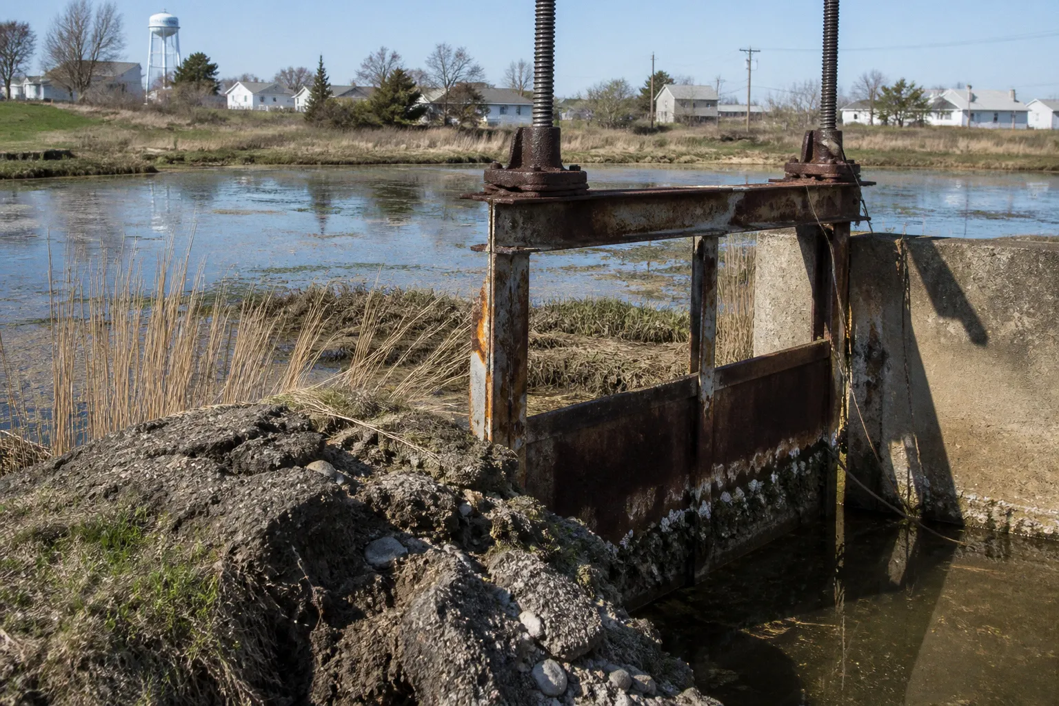
It is a narrow operating margin for roads, homes, pump stations, ditches, and every tide gate expected to keep salt water out while stormwater gets out.
The drainage problem is mechanical before it is political. A tide gate that does not close cleanly, a ditch that has lost capacity, or a pump station sized for yesterday’s runoff can turn an ordinary high tide into standing water on roads and in yards. Somerset County tide gate maintenance therefore cannot be treated as routine vegetation cutting or occasional hardware replacement. It is load-bearing public works.
The county and its municipalities are responding with a combination of tide gate upgrades, pump stations, berms, elevated roadways, bulkheads, ditch assessments, and recurring nuisance-flood planning. The pieces have to work together. A gate alone is not a flood defense system.
The physical problem: low ground, tidal water, limited drainage capacity
Somerset’s drainage network operates under two opposing pressures.
Rainwater needs to move away from roads, homes, and fields through roadside and open ditches. Tidal water pushes in from the opposite direction through creeks, canals, outfalls, and low-lying drainage paths. Tide gates are installed at these connections to allow internal water to discharge while blocking high tide or storm-driven water from moving inland.
That arrangement works only when the gate, the channel, and the receiving water body are all functioning as designed. If one part loses capacity, the entire system backs up.
A drainage ditch can fail without collapsing. Sediment accumulation, vegetation, debris, bank slumping, or a poorly maintained crossing can reduce the effective opening. The water still moves, but more slowly. During a mild rainfall event, nobody notices. During a high tide followed by heavy rain, the same restriction becomes a hydraulic bottleneck.
The county’s exposure is made worse by projected water-level changes. Water levels along Maryland’s shoreline are expected to rise another 1.0 to 1.5 feet between 2000 and 2050. That rise reduces the difference in elevation between inland drainage water and the receiving tidal water. In plain terms, gravity has less room to do its work.
A gate does not create drainage capacity. It only controls the direction of flow. When the outside water level is high, the gate may need to remain closed to prevent tidal intrusion. Internal water then has nowhere to go unless a pump station, storage area, or alternative discharge route is available.
A tide gate is a valve, not a complete flood-control system. If the pumps, ditches, berms, and outfalls cannot carry the load, the gate simply holds the water on the inland side.
This is where many public descriptions of tide gate failures in Maryland become too simple. The visible symptom may be a flooded road or a gate that appears stuck. The underlying failure may be insufficient ditch volume, a blocked outlet, inadequate pumping capacity, settlement around a structure, or a design that no longer matches current water levels. The exact historical failure mechanisms for every rural gate in Somerset County are not established in the available project summaries, so the diagnosis should not be overstated.
The practical response is more disciplined: inspect the whole drainage path, measure where water is being held up, and repair the limiting component rather than replacing hardware in isolation.
How tide gates fail in practice
Somerset County tide gate maintenance begins with distinguishing a gate problem from a system problem. These are related, but they are not interchangeable.
A gate may fail to close because of debris, corrosion, damaged hinges, distorted frames, or an obstruction at the sill. It may close but still leak because the sealing surface is worn or misaligned. A flap-style gate may be physically intact while the water pressure, sediment, or surrounding channel prevents it from operating as intended.
The inspection question is not simply whether the gate moves. The question is whether it performs its intended hydraulic job under the conditions that matter: high tide, rainfall, wind-driven water, and repeated cycles.
A useful field review should establish:
- Whether the gate opens freely toward the discharge side and closes before tidal water reaches the inland drainage network.
- Whether the frame, hinges, flap, seals, and anchoring points show corrosion, deformation, cracking, or settlement.
- Whether sediment or vegetation has reduced the approach channel or the outlet opening.
- Whether nearby pipes, culverts, and ditch crossings are smaller than the gate’s effective opening.
- Whether water remains trapped inland after the gate closes because there is no pump capacity or storage volume.
- Whether the structure can be accessed safely for inspection and maintenance during wet conditions.
- Whether the gate is being asked to manage flows beyond the assumptions used in its original design.
The most common management mistake is to treat maintenance as a calendar event instead of a performance requirement. A gate may be inspected once a year and still fail during the first serious storm if the inspection never included a high-water operating test, debris removal, or review of the upstream ditch network.
That does not mean every gate needs constant mechanical intervention. It means the maintenance schedule should follow exposure and consequence. A gate protecting a low road connection, a dense residential area, or a major drainage outlet deserves more attention than a structure with a large storage area upstream and little development around it.
A practical failure review
When water remains on the inland side of a tide gate, the investigation should proceed in a fixed order.
1. Check the outside water level.
If the receiving creek or canal is already high, the gate may be correctly closed. The problem may be the absence of a pump or insufficient temporary storage, not a defective gate.
2. Check the gate’s physical movement.
Look for debris, seized hinges, damaged frames, and obstruction at the opening. A gate that cannot move through its operating range is a direct maintenance failure.
3. Check the discharge path.
A clear gate cannot compensate for a narrowed culvert, sediment-filled ditch, or blocked outlet. The system must be inspected upstream and downstream.
4. Check pump operation and capacity.
Where pumps are part of the design, verify power, controls, intake condition, discharge routing, and the ability to operate while the gate remains closed.
5. Check the surrounding grade and structure.
Settlement in a roadway, berm, bulkhead, or gate foundation can create a low point that directs water around the intended defense.
6. Record the event.
Water depth, tide stage, rainfall timing, duration of ponding, gate position, pump status, and visible obstructions provide the evidence needed to correct the design rather than guess at it.
This sequence matters because premature replacement can produce budget overruns without restoring drainage capacity. A new gate installed at the same undersized outlet is still an undersized system.
Crisfield’s perimeter defense: gates backed by pumps and elevation
Crisfield’s flood mitigation work shows what a complete defense system looks like on paper. The city has designed tide gates at six key locations:
- 7th Street
- Cove Street
- Somerset Avenue Extended
- Woodson School
- Broad Street and Lumber
- Broad Street and 9th Street
The projects are supported by FEMA and Maryland Department of the Environment funding. The combined FEMA and MDE funding identified for the tide gates and pumps totals $1,379,474.
The important point is not the number of gates. It is the arrangement around them. Crisfield’s perimeter flood defense plan combines berms, elevated roadways, and bulkheads designed to hold back water up to 5 feet above sea level. It also includes three new pump stations intended to remove internal floodwater when the gates must remain closed.
That is the correct engineering logic for a low-lying coastal city. During a high-water event, the defense line has two separate jobs:
1. Keep external water from crossing the perimeter.
2. Remove rainfall and interior runoff trapped behind that perimeter.
A tide gate handles the first job only at its own opening. A pump station handles the second job. Roads, berms, and bulkheads provide continuity between the points of protection. If one of those elements is missing, water will use the weakest path available.
| System component | Primary job | Failure consequence |
|---|---|---|
| Tide gate | Blocks tidal water and permits controlled discharge | Tidal intrusion, backflow, or inability to drain |
| Pump station | Removes interior water while gates are closed | Ponding behind the flood barrier |
| Berm or bulkhead | Maintains the perimeter defense line | Water bypasses the gate through a low section |
| Elevated roadway | Keeps transportation access above flood levels | Road closure even when adjacent structures remain protected |
| Open ditch or culvert | Moves runoff toward the outlet | Upstream flooding and standing water |
| Power and controls | Keeps pumps and gates operational | System failure during the event when it is most needed |
The table is not theory. It is the minimum division of labor. Confusing these components leads directly to bad maintenance priorities. A municipality may spend money on a gate while leaving the pump controls unreliable, or clear a ditch while ignoring a low roadway that allows water to overtop the defense line.
Crisfield’s project history also demonstrates why funding schedules affect physical infrastructure. The available project information indicates that federal funding changes in 2025 required restructuring of the project phase after termination of the BRIC program. That kind of change is not merely administrative. It can alter bid packages, local match requirements, construction sequencing, and the timing of site access.
Projects should therefore be tracked by function, not just by grant name. The ledger should show which gate is under design, which pump station is funded, which road segment requires elevation, and which drainage connection remains unfinished. Otherwise a project can appear active while the load-bearing pieces are still waiting on separate approvals or funding.
Deal Island and the open-ditch problem
The Deal Island Peninsula presents a different version of the same problem. Here, the issue is not only coastal water at the outlet. It is the condition and capacity of the open drainage network serving low-lying communities.
Somerset County commissioned the Deal Island Open Ditch Drainage Assessment with a $75,000 grant from the Maryland Department of Natural Resources. The assessment covers roadside and non-roadside ditch deficiencies in Dames Quarter and Oriole.
That distinction matters. Roadside ditches are visible and often associated with transportation maintenance. Non-roadside ditches may cross private land, agricultural areas, utility corridors, or drainage easements. They can be just as important to the hydraulic system and much harder to maintain consistently.
A ditch assessment should not stop at a list of locations where water has been observed. It should connect each deficiency to the wider drainage route:
- Where does the ditch begin collecting runoff?
- What cross-section and slope remain after sediment and vegetation are removed?
- Does the ditch connect to a culvert, pipe, tide gate, or pump?
- Is the outlet controlled by tide, and if so, how often is discharge blocked?
- Are driveway culverts or road crossings creating local choke points?
- Is the ditch carrying water from more than one property or road segment?
- Who has access and responsibility for maintenance?
- Does clearing one section simply move the bottleneck downstream?
The county’s $75,000 assessment grant is useful because it supports diagnosis before construction. That is the right order. Excavating ditches without a drainage model or field survey can shift erosion, undermine road shoulders, or push water faster into a downstream restriction.
The opposite mistake is deferred maintenance. A ditch left partially blocked year after year loses its working cross-section gradually. By the time flooding becomes politically visible, the repair may require heavy excavation, culvert replacement, easement work, or roadway reconstruction instead of ordinary vegetation control.
The cheapest drainage repair is the one performed before a ditch loses its shape, a shoulder collapses, or a culvert becomes the system’s accidental dam.
Open ditches also require restraint. More excavation is not always better. A deeper or wider ditch may increase storage, but it can also destabilize banks, expose erosion-prone soils, or affect adjacent wetlands and waterways. In the Chesapeake Bay watershed, drainage work has environmental consequences. Sediment leaving a ditch does not disappear; it moves into downstream channels and ultimately contributes to water-quality problems.
The correct target is functional capacity with controlled discharge. That may mean selective clearing, reshaping a short reach, replacing a failed crossing, stabilizing a bank, or restoring a connection to an existing outlet. It does not automatically mean digging every ditch deeper.
Nuisance Flood Plans turn repeated flooding into a management record
Maryland coastal jurisdictions experiencing high-tide flooding are required to prepare and submit a Nuisance Flood Plan to the Maryland Department of Planning every five years.
The five-year cycle is important because coastal drainage conditions are not fixed. Water levels are rising, structures settle, roads are resurfaced, land uses change, and maintenance backlogs accumulate. A plan that accurately described a drainage system several years ago may no longer describe its weak points.
A useful Nuisance Flood Plan should function as an operating document, not a ceremonial filing. It should identify:
- Repeatedly flooded roads and intersections.
- Tide gates that protect critical drainage outlets.
- Pump stations and their backup-power arrangements.
- Ditches and culverts that carry runoff from multiple properties or public facilities.
- Low sections in berms, bulkheads, and roadway approaches.
- Locations where tidal water closes the drainage route before rainfall has cleared.
- Maintenance responsibilities and access constraints.
- Projects that are funded, designed, awaiting permits, or still unfunded.
- The cost of deferred maintenance and the consequence of delaying it.
The plan should also separate nuisance flooding from larger storm events. A road that floods during a major coastal storm requires a different response from a road that floods repeatedly during high tide and moderate rainfall. Both matter, but they point to different investments.
For county and municipal staff, the most useful planning method is to rank locations by consequence rather than by complaint volume alone. A flooded driveway is a real problem. A flooded evacuation route, emergency access road, pump station approach, or only connection between communities carries a different public risk.
That ranking can be made practical with a small set of questions:
1. Does the location remain passable for emergency and maintenance vehicles?
2. Does flooding isolate homes, businesses, schools, or public facilities?
3. Is the problem caused by a correctable obstruction or by a permanent elevation constraint?
4. Can maintenance restore capacity, or is capital construction required?
5. Will the proposed fix continue to work as water levels rise?
6. Does the project protect one parcel, or does it restore a broader drainage route?
The point of the five-year update is not to produce another document that sits on a shelf. It is to keep the work program tied to observed conditions. If a gate has failed three times, the plan should show the repair history. If a ditch has been cleared repeatedly without solving upstream ponding, the plan should show that the maintenance approach is not working.
The money follows the weakest component
Coastal resilience projects rarely fail because nobody understands that water is a problem. They fail because the funding and construction sequence do not match the physical system.
A tide gate may be eligible for one funding source. A pump station may require another. Road elevation may be handled through transportation funds. Ditch work may depend on a grant, a county crew, or access across private property. The result is a fragmented project in which each component is defensible on its own but the full drainage route remains incomplete.
Somerset County’s approach needs to track the entire chain from rainfall to receiving water. For each flood-prone location, the project ledger should identify the controlling restriction. It could be:
- The gate opening.
- The ditch cross-section.
- A culvert under a road.
- The pump station.
- The discharge pipe.
- The height of the road or perimeter barrier.
- The electrical service or control system.
That controlling restriction is where the next dollar should go. Not necessarily to the most visible structure. Not necessarily to the component with the easiest grant application.
A gate replacement that does not improve discharge may have a clean ribbon-cutting and no measurable reduction in ponding. A pump station without dependable power is a concrete box waiting for the next outage. A raised roadway with low approaches simply moves the closure a few hundred feet. These are not hypothetical design errors; they are predictable consequences of treating infrastructure as isolated objects.
Maintenance versus capital work
The distinction between maintenance and capital construction also needs to remain clear.
Routine maintenance includes inspection, debris removal, vegetation control, lubrication where appropriate, minor hardware repair, and clearing accessible drainage paths. Capital work may include new pumps, structural gate replacement, berm construction, bulkheads, roadway elevation, major culvert work, and redesign of the outfall.
When agencies defer routine maintenance, they often force a capital project earlier than necessary. When they label a structural failure as ordinary maintenance, they underfund the repair and prolong the risk. Both errors waste money.
A workable program should maintain an asset register for every significant gate, pump, culvert, ditch connection, and flood barrier. The register does not need to be elaborate. It needs to record condition, access, last inspection, known deficiencies, responsible owner, and consequence of failure.
That information makes budget decisions less speculative. It also helps separate urgent repairs from long-range adaptation. A corroded hinge may need immediate replacement. A road that is repeatedly overtopped because surrounding water levels are rising may require a larger elevation project. Those are different problems with different time horizons.
Designing for a higher receiving water level
The projected 1.0 to 1.5 feet of additional water level along Maryland’s shoreline between 2000 and 2050 changes the operating environment for every tide-controlled drainage outlet.
A system designed around a particular difference between inland water and tidal water will lose performance as that difference narrows. Gravity discharge will become less reliable during high tide. Gates will remain closed for longer periods. Pumps will carry more of the workload. Ditches and storage areas will need to hold water until discharge becomes possible or mechanical removal takes over.
That has direct implications for equipment sizing and maintenance:
- Pumps need sufficient capacity for the expected interior drainage area, not merely the current average event.
- Pump inlets must remain clear when sediment and debris are present.
- Electrical systems and controls must be protected from flooding.
- Backup power must be treated as part of the drainage asset, not an optional accessory.
- Discharge pipes must be checked for backflow and submergence conditions.
- Gates must be accessible when roads and surrounding ground are already wet.
- Structural details must account for repeated loading, corrosion, and settlement.
- Ditches must retain enough storage and conveyance capacity during periods when outlets are closed.
The goal is not to promise that Somerset can eliminate flooding. No honest infrastructure plan can make that promise in a low-elevation coastal county. The goal is to reduce the frequency, duration, and consequence of flooding while preserving routes and services that communities depend on.
That means making hard choices. Some locations will justify engineered protection. Others may be better served by improved drainage, raised access, floodproofing, or changed maintenance practices. In every case, the decision should begin with the physical constraint: elevation, receiving-water level, available storage, flow path, and cost.
A more reliable operating standard for Somerset
Correcting Somerset drainage errors requires a shift from isolated repairs to connected asset management.
For tide gates, that means testing operation, clearing obstructions, checking structural alignment, and reviewing the ditch and culvert network behind the gate. For pumps, it means verifying capacity, power, controls, intake condition, and discharge performance. For roads and berms, it means finding the low points that allow water to bypass the intended protection line. For open ditches, it means restoring useful cross-section without creating new erosion or water-quality problems.
The work can be organized around five operating rules:
1. Inspect the entire drainage route, not only the gate.
The failed component may be several hundred feet upstream or downstream from the visible flooding.
2. Treat pump capacity as essential whenever gates close against high water.
Without a pump or adequate storage, the system has no way to remove interior runoff during the period of greatest tidal restriction.
3. Use field records to set maintenance priorities.
Repeated flooding, failed operations, inspection findings, and repair costs should determine the work program.
4. Match the project to the controlling constraint.
Do not replace a gate when the ditch, culvert, power supply, or outfall is the actual bottleneck.
5. Design new work for future water levels, not only current conditions.
A repair that functions today but loses discharge capacity as sea levels rise is deferred failure with a new invoice.
Somerset County’s flood defense work is not short on urgency. The county has the low elevations, the tidal exposure, the drainage limitations, and the rising water levels to make delay expensive. The useful response is not another broad resilience slogan. It is a maintained gate, a clear ditch, a reliable pump, a defensible road elevation, and a project ledger that shows what remains unfinished.
That is the standard. The water does not care which agency owns the component. A drainage system either carries the load or it does not.