Living Shorelines: How They Protect Somerset County
If you've driven down to the bay lately and watched the marsh grass pulling back from the waterline—foot by foot, season by season—you've probably wondered what, if anything, anyone is doing about it.
Maybe you've seen the bright tape marking off oyster spat along a neighbor's bulkhead, or heard folks at the diner talking about a "living shoreline" project going in down the road. Maybe you've even tried to figure out who's behind it and whether it's going to help the place you call home.
We get it. Coastal erosion sounds like one of those big, distant problems until you watch a chunk of your shoreline disappear in a single nor'easter. That's exactly why living shorelines have moved from a niche conservation idea to one of the most important pieces of infrastructure we're investing in across Somerset County. And right now, with more than $4.5 million in new state grants flowing to seven living shoreline projects across the Eastern Shore—four of them right here in Somerset County—there's a real opportunity to understand what's happening, why it matters to your block, and how you can be part of the conversation.
The Evolution of Coastal Protection: From Bulkheads to Living Shorelines
For most of the last century, the default answer to shoreline erosion was simple: pile up rocks, drive in sheet metal, pour some concrete. Bulkheads, riprap revetments, and seawalls did what they were designed to do—hold the line. The problem is that they hold the line by fighting the water, and the water always wins eventually. Hard structures reflect wave energy rather than absorbing it, which scours the seabed in front of them, kills the marsh edge that used to break waves naturally, and often accelerates erosion on neighboring properties.
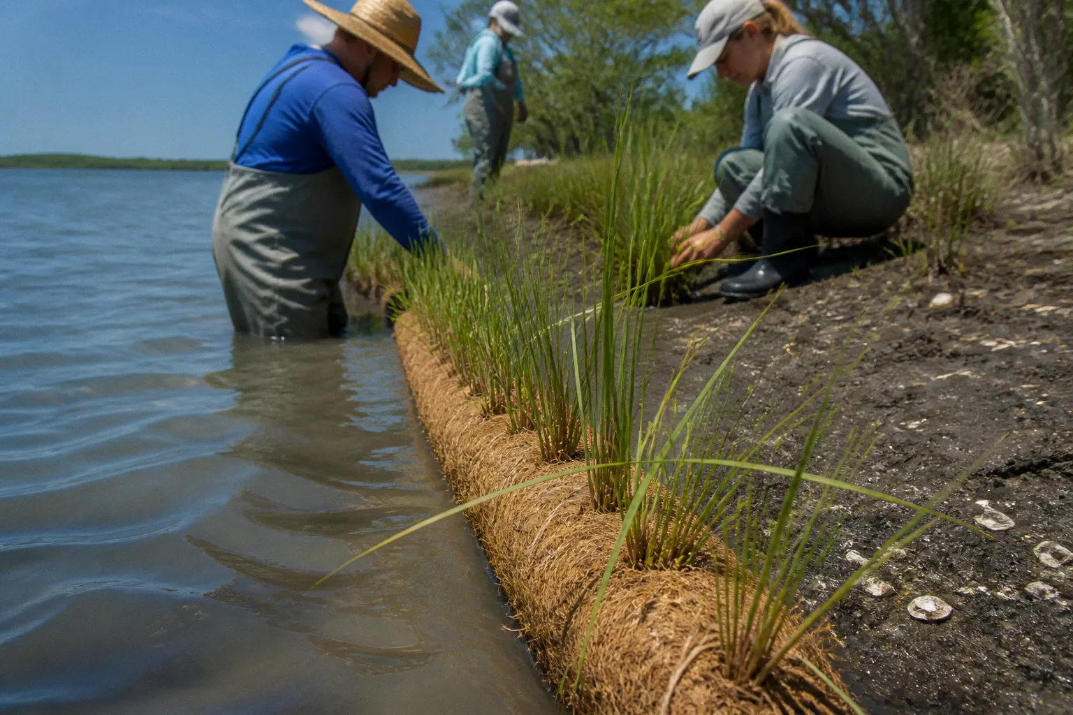
A living shoreline takes the opposite approach. Instead of blocking the water, it works with it. We're talking about a combination of native marsh plantings, sand or coir fiber logs, oyster reefs, and sometimes low-profile rock sills set just offshore to absorb wave energy before it reaches the bank. The result is a shoreline that grows stronger over time, traps sediment, supports fish and crabs, and gives birds a place to nest.
A living shoreline doesn't just hold back water—it builds back the marsh that nature used as its own first line of defense.
The shift in Maryland policy followed that understanding. The Maryland Living Shoreline Protection Act of 2008 set a clear preference: property owners seeking new shoreline stabilization must use nonstructural, nature-based methods unless they can demonstrate to the Maryland Department of the Environment that those methods are not feasible at their site. It didn't tear down existing bulkheads, but it changed what comes next—and it gave state agencies the framework to invest in the alternatives.
Roots for Resilience: Scaling Nature-Based Infrastructure in Somerset
In May 2026, the Maryland Department of Natural Resources officially launched "Roots for Resilience," an initiative backed by $42.5 million in federal grant funding through the U.S. Environmental Protection Agency's Climate Pollution Reduction Grant program. The program set aside roughly $17 million specifically for living shoreline restoration work, and in late June 2026, DNR announced the first major round of awards: more than $4.5 million directed to seven living shoreline projects on the Eastern Shore, four of which are right here in Somerset County.
That matters because it means our county is now home to the densest cluster of these projects on the Chesapeake. And it signals how seriously the state is taking the idea that nature-based infrastructure isn't a "nice to have"—it's load-bearing, in the same way that a road or a bridge is load-bearing.
The way the funding is structured is worth understanding. The June 2026 grants primarily cover the design phase of these projects—engineering, permitting, surveying, and the studies regulators need to approve construction. Once those designs are signed off and the regulatory boxes are checked, construction dollars follow in later rounds. So when you hear about a project being "funded," that doesn't mean bulldozers are showing up next month. It means the planning work is paid for and the project is moving forward in line.
Here's a quick look at how the four Somerset County projects stack up against one another:
| Project Site | Lead Organization | Marsh Area Protected | Habitat Focus |
|---|---|---|---|
| Deal Island (Little Deal) | Alliance for the Chesapeake Bay | 78 acres | Deal Island Wildlife Management Area |
| Franks Island | Somerset County | 72 acres | Deal Island Causeway protection |
| Pocomoke Sound | Lower Shore Land Trust | 200+ acres | Diamondback terrapin, saltmarsh sparrow |
| Smith Island | Ducks Unlimited | 118 acres | Martin National Wildlife Refuge, migrating waterfowl |
Each of these sites is doing slightly different ecological work, but they're all part of the same story: rebuilding the ribbon of marsh that buffers our communities from storms and keeps the bay healthy.
Strategic Marsh Restoration: Key Projects in Deal, Franks, and Smith Islands
Let's walk through what's actually being planned, because the differences between these projects tell you a lot about how restoration works in practice.
The Deal Island project, led by the Alliance for the Chesapeake Bay, will work within the Deal Island Wildlife Management Area at Little Deal Island. The goal is to protect 78 acres of marsh that has been taking a beating from boat wakes, storm surge, and the slow creep of sea level. When you protect marsh here, you're not just protecting habitat—you're protecting the shoreline that protects the road, the homes, and the working waterfront on the mainland side of the causeway.
Deal Island is also familiar territory for this kind of work. Back in April 2021, Somerset County itself received roughly $1.17 million through the DNR Coastal Resiliency Program to construct a 1,100-linear-foot living shoreline with dune restoration and offshore breakwaters in Tangier Sound—a project that wrapped up the following year and gave the county real, on-the-ground experience with how these systems perform under actual storm conditions. The four new projects build on that foundation rather than starting from scratch.
Just across the way, the Franks Island project is being managed by Somerset County. This 72-acre effort is specifically designed to bolster storm resilience around the Deal Island Causeway, which is one of those pieces of infrastructure most folks don't think about until they can't use it. A causeway that floods or washes out doesn't just inconvenience commuters; it cuts off emergency services, school buses, and supply runs to an entire community.
Over on the Pocomoke Sound, the Lower Shore Land Trust is designing a living shoreline along a conservation easement that protects more than 200 acres of salt marsh. That acreage is significant because it's home to species that have been quietly disappearing from other parts of the Chesapeake—most notably the diamondback terrapin, the only turtle in North America that lives exclusively in brackish and tidal saltwater, and the saltmarsh sparrow, a bird so tied to our coastal marshes that conservationists consider its survival closely linked to the persistence of these habitats.
Out at Smith Island, Ducks Unlimited is taking the lead on a project within the Martin National Wildlife Refuge, targeting 118 acres of marsh that migrating waterfowl rely on as a refueling stop along the Atlantic Flyway. Smith Island's remoteness makes projects like this logistically tricky, but the ecological payoff is substantial: this is one of the most intact marsh complexes left in the mid-Atlantic.
Each project is a small piece of a much larger goal: 400 acres of high-quality tidal marsh protected across the region by 2029.
The collective target across the Roots for Resilience portfolio is 400 acres of high-quality tidal marsh habitat by 2029. That number sounds abstract until you think about what an acre of healthy marsh actually does: it stores floodwater, dampens wave energy, and reduces the force of storm surge reaching homes and roads behind it—all while supporting crabs, oysters, fish, and birds that a concrete wall never could.
Navigating the Maryland Living Shoreline Protection Act of 2008
Now, here's where we get into the part that often confuses residents: the regulatory side. If you own waterfront property in Somerset County and you're thinking about stabilizing your bank, the rules have changed significantly since 2008.
Under the Maryland Living Shoreline Protection Act, you cannot simply default to a bulkhead or a seawall. The law establishes a clear preference: you must use a nonstructural, nature-based approach—marsh creation, vegetation, oyster reefs, or similar techniques—unless you can make a documented, technical case to the Maryland Department of the Environment that those methods are not feasible at your specific site. "I prefer a wall" isn't enough. "The wave energy at this exact location exceeds what marsh plantings can handle, and here's the engineer's analysis" is closer to what MDE will want to see.
What the law does not do is force you to tear out an existing bulkhead. If you already have a hardened shoreline that's still functional, the act doesn't compel you to replace it with a living one. The requirement kicks in when you're planning new stabilization or full replacement of an aging structure.
For most homeowners in Somerset County, navigating this board of decisions comes down to a few practical steps:
- Before you hire a contractor to "fix" the bank, talk to your county's planning office and to MDE first. The conversation is shorter and cheaper than you think.
- A living shoreline project can sometimes be paired with cost-share funding through state programs, which can offset a meaningful portion of design and construction costs.
- The permitting pathway for a nature-based project is generally smoother than for a hardened structure, because the regulators are already leaning your direction.
If you're not sure where to start, the Lower Shore Land Trust and the Alliance for the Chesapeake Bay are both good community resources—they work on these projects every day and can often point you toward the right technical partners.
Long-Term Ecological Impact and Future Funding Horizons
Here's the part that doesn't always make it into the press release: living shorelines are living systems. They grow, they shift, and they require some stewardship in the early years—primarily weed control, replanting of failed sections, and routine monitoring. They aren't immune to extreme storm damage any more than a backyard garden is immune to a hurricane, but the data we have so far suggests they recover far faster than bulkheads do, and they keep providing ecological function in the meantime.
The long-term ecological gains add up across the watershed. A marsh edge that's trapping sediment and supporting juvenile crabs is a marsh edge that's slowly building itself higher in step with sea level. A fringing oyster reef is filtering water and providing fish habitat. The saltmarsh sparrow and the diamondback terrapin, both of which depend on these brackish and tidal marsh habitats, get a fighting chance at persistence. And the communities behind those marshes get a softer, more resilient buffer against the next storm.
Looking ahead, the funding landscape is more encouraging than it's been in years. The Roots for Resilience initiative runs through 2029, with the goal of protecting those 400 acres of tidal marsh. Federal climate money is flowing into nature-based infrastructure for the first time at meaningful scale, and Somerset County is positioned—thanks to those four project sites—to be a flagship for how the Eastern Shore adapts to a wetter, saltier future.
For our part, the most useful thing we can do as a community is pay attention. Show up at the public meetings when these projects go through the planning commission. Ask good questions of the county staff. Support the local land trusts that are doing the boots-on-the-ground work. And if you live along the water, take seriously what the Living Shoreline Protection Act has been telling us for almost two decades: the cheapest, most durable way to hold a shoreline isn't a wall. It's the marsh that nature keeps trying to grow there, if we let it.