Nuisance flooding: how tidal rises affect Somerset roads
A road does not need to disappear under a hurricane to become a serious transportation problem.
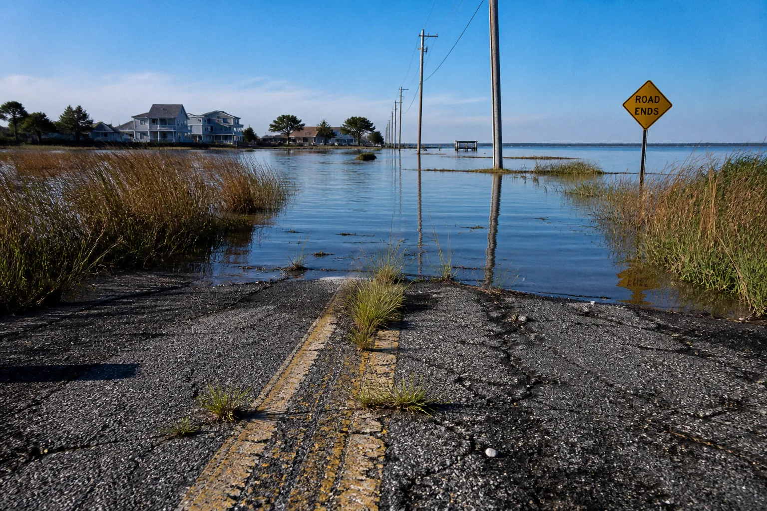
In Somerset County, a high tide on an otherwise calm day can push water onto low-lying roads, overwhelm drainage systems, and make a familiar route difficult—or temporarily impossible—to use. That is the practical reality behind nuisance flooding on Maryland’s Eastern Shore, also called high-tide flooding or sunny day flooding.
For residents, the question is rarely just whether water is present. It is whether you can get to work, reach a medical appointment, move school buses safely, receive deliveries, or reach a neighborhood after an emergency. What this means for your block depends on elevation, nearby waterways, the condition of ditches and culverts, and whether the road has a reliable way to shed water when the tide rises.
Somerset County faces this challenge at an unusually large scale. The county contains approximately 1,100 miles of waterfront property, while only about 10 percent of its land rises above 20 feet in elevation. Saltwater marshes cover roughly 23 percent of the county, and freshwater marshes cover another 6 percent. Much of the landscape is productive precisely because it is flat and water-connected—but those same qualities make transportation and drainage more vulnerable.
What nuisance flooding means for Somerset County
Nuisance flooding is not limited to named storms. Under Maryland law, the term refers to high-tide flooding that creates a public inconvenience. That wording may sound modest, but repeated inconvenience can become a substantial infrastructure burden when it affects the same road, intersection, culvert, or drainage outlet again and again.
The pattern is familiar across low-lying parts of the Eastern Shore:
1. Tidal water rises in a nearby river, sound, bay, or creek.
2. The receiving water is already high, so stormwater has nowhere to go.
3. Ditches, pipes, and culverts drain more slowly—or back up.
4. Water reaches the road surface, shoulders, or adjoining properties.
5. The road becomes less reliable even though there may be no heavy rain and no major storm.
Somerset County’s exposed waterways include Tangier Sound, the Manokin River, the Pocomoke River, Pocomoke Sound, Monie Bay, the Wicomico River, and the Big and Little Annemessex Rivers. A road near one of these systems does not need to sit directly on the shoreline to feel the effects. Tidal water moves through connected channels, marshes, drainage networks, and low ground, creating problems that can extend inland from the visible waterfront.
Sunny day flooding is still an infrastructure event when it repeatedly interrupts the roads, drainage systems, and daily routines our community depends on.
The geography makes the county’s situation different from a conventional urban stormwater problem. Approximately two-thirds of Somerset County’s land area has been ditched to help with drainage, yet only about 10 percent of county soils drain well enough for farming without artificial drainage. The drainage network is not an optional layer added to an otherwise dry landscape. It is part of how the landscape functions.
That also means a ditch or culvert cannot be evaluated in isolation. A drainage improvement may move water away from one location while placing more pressure on a downstream outlet. If that outlet is tide-locked or already submerged, a larger pipe alone will not solve the problem.
Why roads flood even when the weather is calm
When people hear about coastal flooding, they often picture a storm surge driven by a hurricane or nor’easter. Those events can certainly create dangerous conditions, but nuisance flooding works on a quieter schedule. The trigger may simply be an unusually high tide, elevated water levels in a connected river, or a combination of high tide and recent rainfall.
The road is where the problem becomes visible, but the cause is usually a system of interacting conditions.
Low elevation leaves little room for error
In a very flat county, a small change in water level can affect a wide area. With only a limited portion of the landscape standing above 20 feet, many roads and drainage features operate close to the level of nearby tidal waters. There may be no steep slope to carry runoff away and no natural elevation difference to keep floodwater separated from the roadbed.
This is one reason that a route can flood repeatedly without looking dramatically different from surrounding roads. A few inches of water at the wrong point can cover a low shoulder, hide pavement damage, or block a culvert entrance.
Tidal water can reverse the drainage equation
Most drainage systems are designed around the assumption that water will flow from higher ground toward a lower outlet. During a high tide, that outlet may be partially or completely submerged. The ditch can still be open, the pipe can still be intact, and the system can still fail to drain because the receiving water is higher than the water trying to leave.
That distinction matters when we are navigating the board or discussing a proposed public works project. Clearing vegetation from a ditch may be useful. Replacing a collapsed culvert may be necessary. But neither measure guarantees that water will move during the highest tides. The receiving environment has to be part of the design.
Saltwater changes the maintenance problem
Repeated exposure to tidal water can affect more than the road surface. Saltwater can accelerate deterioration of metal components, contribute to shoulder erosion, and damage vegetation that was not suited to regular salt exposure. Water that sits on or beside a roadway can weaken the base over time, even when each individual flooding episode seems minor.
The long-term concern is not only a single closure. It is the accumulation of smaller repairs: resurfacing, shoulder work, ditch maintenance, culvert replacement, traffic control, and emergency response. A community may experience these costs as separate line items, while residents experience them as one ongoing reliability problem.
Rain and tide can compound each other
A rainfall event becomes more difficult to manage when the tide is already high. The same drainage network that might handle ordinary rain can struggle when the outlet is constrained by tidal water. This is why a road may flood after a moderate storm in one cycle but remain passable after heavier rain in another.
For residents, the practical lesson is straightforward: precipitation totals do not tell the whole story. Tide timing, wind direction, recent rainfall, water levels in nearby rivers, and the condition of local drainage all affect what happens on the ground.
The 2021 flooding event showed the scale of the risk
On October 29, 2021, Somerset and Dorchester counties experienced the worst Chesapeake Bay tidal flooding in 50 years. In multiple locations, water levels exceeded those recorded during Superstorm Sandy.
That event is important because it demonstrates that tidal flooding is not merely a theoretical future concern. A regional water event can produce serious impacts without fitting the public image of a catastrophic hurricane. It also shows why road planning cannot focus only on emergency response after a storm. Some of the most disruptive conditions may arrive through a combination of tide, wind, and geography rather than through a single dramatic weather headline.
The 2021 event also gives residents a useful way to think about resilience. A road that remains open during ordinary high tides may still be vulnerable during an exceptional tidal event. Conversely, a road that floods repeatedly during smaller events may be signaling where a larger failure could occur later.
The purpose of a nuisance flood plan is to identify and manage these recurring vulnerabilities before they become a crisis. Under Maryland House Bill 1427, local jurisdictions experiencing nuisance flooding were required to develop a nuisance flood plan by October 1, 2020, and update it at least every five years. Somerset County adopted an initial nuisance flooding plan in 2019 and updated it in 2024. The county also adopted a Multi-Hazard Mitigation Plan in 2022.
These documents are not substitutes for construction, maintenance, or funding. They are the framework that helps connect individual flooding reports to broader decisions about roads, drainage, land use, emergency access, and future investment.
What a resilient road project has to solve
A useful coastal resilience project begins with a specific failure, not a general promise to make the area stronger. We need to know what is flooding, how often it happens, what the road serves, and which part of the drainage system is limiting performance.
When a county or municipality studies a vulnerable road, several questions help separate a durable solution from a temporary repair:
- Is water arriving from the roadway’s watershed, from a nearby tidal channel, or from both?
- Does the road flood because the pavement is too low, because the shoulder has eroded, or because the outlet is tide-locked?
- Is the affected segment an isolated low point or part of a longer route with several weak locations?
- Does the road provide access to homes, farms, businesses, schools, emergency services, or evacuation routes?
- Would raising the road simply move water toward adjacent properties?
- Can a proposed culvert, tide gate, pump, or berm be maintained over time?
- Will the project remain useful as tidal water levels continue to change?
The options are not interchangeable. Each addresses a different part of the problem.
| Approach | What it can address | What it cannot solve by itself |
|---|---|---|
| Road elevation | Keeps the travel surface above recurring flood levels and may preserve access along a defined segment | Can redirect water, affect adjoining properties, and require careful connection to nearby road grades |
| Culvert replacement | Restores or improves drainage where a pipe is undersized, blocked, or damaged | Does not guarantee outflow when the receiving water is high |
| Ditch maintenance | Improves conveyance through existing drainage corridors | Cannot overcome a submerged or restricted downstream outlet |
| Tide gates | Limits tidal water from moving back through a drainage system | Requires maintenance and can restrict drainage when not properly operated |
| Pump stations | Moves water when gravity drainage is unavailable | Requires dependable power, equipment upkeep, and a clear operating plan |
| Berms or bulkheads | Provides a physical barrier against tidal water in selected locations | Can shift water pressure, require substantial upkeep, and may not protect every road or property |
| Marsh and shoreline projects | Preserves natural storage and can reduce wave energy in appropriate settings | Cannot replace road-specific improvements where the travel surface is already too low |
The right answer may combine several of these approaches. In a rural coastal county, resilience is often less about one large wall and more about making a connected system perform better: road elevations, drainage outlets, pumps, marsh edges, emergency routes, and maintenance responsibilities all have to fit together.
Crisfield’s flood mitigation approach
The City of Crisfield has designed a flood mitigation plan that includes a perimeter barrier made up of berms, elevated roadways, and bulkheads. The planned defense is intended to hold back water up to five feet above sea level, along with tide gates and three new pump stations.
The significance of this approach is not that every Somerset community should copy it. Crisfield’s geography, development pattern, waterfront exposure, and infrastructure needs are specific to the city. Its plan does show, however, how coastal resilience can require a portfolio of measures rather than a single construction project.
A barrier can reduce exposure in one area, while elevated roads preserve access and pump stations manage water that still enters the protected zone. The details matter: where gates are located, who operates them, how pumps receive power, and what happens when rainfall arrives at the same time as a high tide.
How residents can follow a flooding problem from report to decision
If a road near your home floods repeatedly, the most useful public conversation begins with a clear description of the pattern. A single report that says “the road floods” is harder to act on than a record showing where water appears, under what conditions, and what access is affected.
You can make the issue easier for public works staff, emergency managers, elected officials, and planning boards to understand by documenting:
1. The exact location. Note the nearest intersection, driveway, bridge, culvert, or recognizable landmark. A photo is more useful when the location is clear.
2. The conditions. Record whether the flooding followed rain, occurred during a high tide, or appeared on a calm day without recent rainfall.
3. The depth and reach. If it is safe to do so, describe whether water covers the lane, shoulder, entrance to a property, or drainage structure. Do not enter moving or contaminated floodwater to take a measurement.
4. The timing. Repeated observations over several tide cycles can show whether the issue is occasional or tied to a predictable pattern.
5. The consequence. Explain whether the flooding blocks a route, limits emergency access, affects school transportation, prevents deliveries, or isolates residents.
6. The drainage feature. Include visible information about blocked inlets, damaged culverts, eroded shoulders, standing water, or water flowing back from a ditch.
7. The history. If the same location has been repaired before, identify what changed and how long the improvement remained effective.
This kind of record does not replace an engineering survey, but it gives the survey a better starting point. It also helps our community distinguish between a maintenance request and a capital project. A blocked culvert may need prompt attention. A road that repeatedly floods because its elevation is below tidal water may need a larger resilience strategy.
When a project reaches a public meeting, listen for the connection between the proposed fix and the documented failure. A strong proposal should explain the design water level, the drainage route, the effects on neighboring properties, the maintenance plan, and the conditions under which the road could still flood.
That is not about treating a board meeting like a contest. It is about making the decision understandable enough that residents can see how the project is supposed to work.
The most useful question is not simply, “Will this road be raised?” It is, “Where will the water go when the tide is high?”
How nuisance flooding should shape transportation planning
Transportation planning in Somerset County has to account for more than pavement condition and traffic volume. A lightly traveled road may still be essential if it is the only connection for a rural neighborhood, a farm operation, a waterfront business, or emergency responders. Reliability matters even when a route does not carry a large number of vehicles.
This is especially important for communities with limited alternate routes. In a dense street network, drivers may detour around a flooded block. In a rural coastal setting, the next usable road may be several miles away—or may face the same tidal conditions.
A transportation plan that incorporates nuisance flooding should consider:
- Which roads provide the only access to homes or working waterfronts.
- Whether a flooded segment divides a community from medical, grocery, or public services.
- How school buses, paratransit, and rural transit respond when the normal route is blocked.
- Whether emergency vehicles can use an alternative route during a high tide.
- Which bridges, culverts, and low shoulders are shared by several drainage areas.
- Whether road improvements support or conflict with watershed and marsh management.
- How future development could increase runoff or place more people in low-lying areas.
The connection to land use is direct. A new development next to an already stressed drainage corridor can change the amount and timing of runoff. A parking area, widened driveway, or filled wetland can remove storage that previously helped slow water. In the Chesapeake Bay Critical Area and other environmentally sensitive locations, decisions about construction and shoreline changes can affect both habitat and infrastructure.
That does not mean every development proposal is automatically inappropriate. It means the review needs to account for the whole community fabric, including residents who may live downstream or along the same road. The question is not only whether a parcel can be developed, but whether the surrounding drainage and transportation systems can continue to function.
Planning for a changing shoreline without losing the human scale
Coastal resilience can become abstract when it is discussed only through maps, projections, and capital budgets. For residents, the effects are more immediate: a missed appointment, a closed road, a flooded ditch, a damaged driveway, or the worry that an older neighbor cannot get out during the next high-water event.
That human scale should remain part of infrastructure planning. A technically sound project can still fall short if residents do not understand what it protects, what it does not protect, or who will maintain it. Clear communication is not an accessory to resilience work. It is part of making the work function.
When public agencies explain a nuisance flood plan or road project, the most helpful information usually includes:
- The specific flooding problem being addressed.
- The waterways and drainage areas connected to the site.
- The level of flooding the project is designed to manage.
- The roads, homes, businesses, and public services expected to benefit.
- The properties or roads that may experience changed water flow.
- The maintenance, inspection, and operating responsibilities.
- The remaining risks after construction.
- The process for reporting new or recurring flooding.
We should also be realistic about limits. No single plan can make a low-lying county permanently immune to water. A barrier can be overtopped. A pump can fail. A road can remain vulnerable at its approaches even after the center is raised. A drainage improvement can require continued clearing and inspection.
Resilience is therefore a continuing public works responsibility, not a one-time finish line. The five-year update cycle required for Maryland nuisance flood plans creates an opportunity to compare assumptions with what residents are actually seeing on the ground. If a road floods more often, if a drainage outlet is no longer performing as expected, or if a previous project changed the pattern of water movement, those observations belong in the next planning cycle.
The practical takeaway for Somerset residents
Nuisance flooding on the Eastern Shore is not simply a shoreline issue and not only a storm emergency. In Somerset County, tidal water interacts with very low elevations, extensive marshes, artificial drainage, rural roads, and limited alternate routes. The result is a transportation problem that can appear during ordinary high tides and become much more severe when rain, wind, and elevated water levels arrive together.
For your block, the most important starting point is to understand the local pattern. Identify the low points, watch how tide and rainfall affect the road, document repeat flooding safely, and follow the public process when a plan or project comes forward. Ask how the proposed solution handles the receiving water, not just the pavement. Ask what happens to nearby properties. Ask who will maintain the system after the ribbon-cutting moment has passed.
Our community does not need to choose between accepting repeated flooding and building an oversized barrier everywhere. The better path is more attentive and more local: maintain the drainage systems that can be maintained, elevate or redesign the roads that need structural changes, preserve marshes that help store water, and make transportation decisions around the people who depend on each connection.
That is how a nuisance flood plan becomes more than a document. It becomes a practical way to protect access, guide investment, and keep Somerset County’s infrastructure connected to the landscape it serves.