Nuisance flooding: Why Somerset roads flood on sunny days
A road can close in Somerset County without a hurricane, thunderstorm, or dramatic weather forecast.
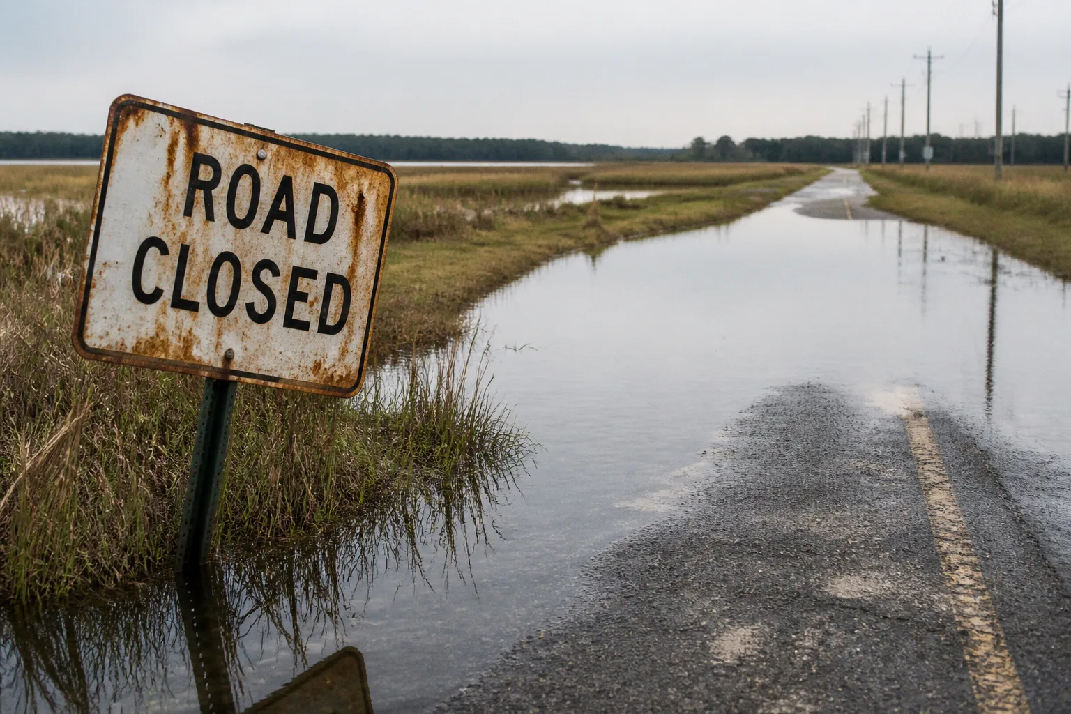
On the Eastern Shore, high tides can push water onto low-lying roads during otherwise ordinary days, disrupting commutes, school routes, deliveries, emergency access, and the small routines that hold a community together. This is nuisance flooding, also called high-tide or sunny-day flooding.
The name can sound almost harmless. The effects are not. When tidal water repeatedly reaches roads and properties, the problem is no longer a one-off inconvenience; it becomes an infrastructure, planning, and public-safety question. That is why Somerset County adopted its 2024 Nuisance Flood Plan and why Maryland requires coastal jurisdictions to prepare and update these plans every five years.
For residents, the central point is simple: sunny-day flooding is not mainly a drainage problem caused by a sudden downpour. It is a coastal change problem, shaped by rising relative sea levels, land subsidence, and the gradual loss of natural barriers. What this means for your block depends on elevation, road design, nearby waterways, shoreline conditions, and how often tidal water can reach the same route.
The mechanics of sunny-day flooding: beyond storms
Nuisance flooding happens when high tides reach places that historically stayed dry. No major storm is required. The tide itself provides the immediate trigger, while longer-term changes make it possible for that water to travel farther inland and remain a recurring presence.
Three forces matter most:
- Relative sea level rise: Water levels are increasing in relation to the land, changing the baseline from which each high tide begins.
- Land subsidence: In some coastal areas, the ground is gradually sinking, which effectively increases the depth and reach of tidal water.
- Loss of natural barriers: Wetlands, dunes, shorelines, and other natural features can slow or absorb water. When those protective systems are reduced or altered, low-lying roads and properties become more exposed.
This is why a resident may see flooding on a clear morning and still be dealing with a coastal hazard rather than a conventional stormwater event. A blocked roadside ditch or undersized culvert can certainly create local drainage trouble, but nuisance flooding has a different starting point: tidal water is entering the landscape because the relationship between the land and the water has changed.
That distinction matters when communities decide what to do next. A stormwater pipe may help move rainwater away from a road. It cannot, by itself, solve a situation in which the receiving waterway is already elevated and tidal water is moving back toward the road. In those places, raising a roadway, improving a crossing, protecting a shoreline, preserving wetland function, or changing how new construction is designed may be part of the answer.
Sunny-day flooding is a warning that the ordinary high tide is reaching places our roads and buildings were not designed to handle.
The phrase “nuisance” describes the lower-severity, high-frequency nature of the flooding, not the importance of the problem. One closure may be inconvenient. Repeated closures can affect access to homes, businesses, farms, public services, and emergency routes. The community fabric is shaped by these practical connections, and flooding can weaken them one route at a time.
Why the Eastern Shore is seeing more of it
Across the United States, coastal nuisance flooding has increased between 300% and 925% since the 1960s, according to NOAA. The increase reflects the combined effects of relative sea level rise, land subsidence, and the loss of natural barriers.
The statistic is national, but the underlying pattern is especially relevant to low-lying communities on Maryland’s Eastern Shore. In Somerset County, the question is not simply whether a large storm will arrive. It is how often ordinary tidal conditions can interrupt daily life, and which roads, parcels, shorelines, and public facilities are most exposed.
The word “relative” is useful here. It describes the relationship between the water and the land, rather than focusing only on the height of the ocean. If water levels rise while the land remains stable, exposure increases. If the land also subsides, the same tide can reach farther or sit higher relative to roads and building sites. From the perspective of a resident trying to leave home or reach a nearby town, the cause may be complex, but the result is direct: a familiar road no longer functions as reliably as it once did.
Nuisance flooding and storm flooding are not the same
These events can overlap, but they should not be treated as interchangeable.
| Feature | Nuisance or sunny-day flooding | Storm-related flooding |
|---|---|---|
| Immediate trigger | High tide and elevated coastal water levels | Storm surge, heavy rainfall, strong winds, or a combination |
| Typical pattern | Lower severity but more frequent and repetitive | Often less frequent but potentially more severe |
| Weather requirement | Can occur on a clear day | Usually connected to a storm system or intense rainfall |
| Main planning concern | Chronic disruptions to roads, access, and property use | Emergency response, damage reduction, evacuation, and recovery |
| Common infrastructure question | Can the road, crossing, shoreline, or facility function under recurring tidal exposure? | Can the community withstand and recover from a major event? |
This comparison helps prevent a common planning mistake: waiting for a dramatic disaster before treating the risk seriously. Repeated minor flooding can damage pavement, accelerate corrosion, undermine shoulders, and make an access route unreliable long before a major storm exposes the same weakness at a larger scale.
It also helps residents describe what they are seeing. If a road floods during a high tide on a clear day, that observation belongs in a different conversation from a flooded intersection after several hours of intense rainfall. Both are infrastructure concerns, but the solutions may involve different agencies, studies, and design choices.
What saltwater intrusion means for Somerset’s landscape
Floodwater on a road is visible. Saltwater intrusion can be quieter, extending its effects into land, soil, vegetation, drainage patterns, and property value.
As sea levels rise, saltwater can move into areas that were previously less affected. That does not mean every parcel faces the same exposure or that every change happens at the same pace. Low elevation, proximity to tidal water, soil conditions, drainage connections, and shoreline characteristics all shape local vulnerability.
In Somerset County, saltwater-impacted land plots increased by 28.6%, representing more than $97 million in total land value. That figure gives the issue an economic dimension, but it should not obscure the human one. Land is not only an entry on a tax record. It may support a home, a farm operation, a business, a habitat, or a route that neighbors use every day.
For our community, this is where coastal resilience becomes more than a shoreline project. A parcel can be affected by changing water conditions even when the owner does not see standing water at the front door. Salt can influence the suitability of land, the health of vegetation, maintenance needs, and long-term decisions about where and how to build.
That is why a useful local discussion asks several questions at once:
- Is the property connected to a tidal creek, marsh, river, or drainage channel?
- Does water remain after high tide, or does it recede quickly?
- Is the road serving the property already vulnerable, even if the parcel itself appears dry?
- Could a shoreline, wetland, or living shoreline reduce exposure without simply shifting water toward a neighboring property?
- Will a proposed improvement continue to work as water levels change?
These are not questions residents must answer alone. They are the kinds of questions that make public planning more specific and more useful. Instead of discussing coastal flooding as an abstract countywide threat, we can connect it to the road we use, the culvert near the intersection, the public building that needs dependable access, or the shoreline that protects a neighborhood.
The Nuisance Flood Plan is a planning requirement, not a suggestion
Maryland law requires coastal local jurisdictions to develop and submit a Nuisance Flood Plan to the Maryland Department of Planning every five years. Somerset County formally adopted its 2024 Nuisance Flood Plan to establish policies and mitigation strategies for low-severity, high-frequency tidal flooding.
That recurring update matters because flood conditions, infrastructure needs, development patterns, and available resilience practices do not remain fixed. A plan written once and placed on a shelf would quickly lose value. The five-year cycle creates a structure for revisiting risks and adjusting policies as local conditions become clearer.
A Nuisance Flood Plan is best understood as a bridge between observed problems and public decisions. It can help a county move from questions such as “Why does this road keep flooding?” toward more actionable ones:
1. Where does tidal flooding occur repeatedly?
The first step is to identify locations and patterns rather than treating every flooded road as an isolated incident.
2. Which public functions are affected?
A road serving a single low-density area and a route connecting residents to schools, health services, employment, or emergency facilities may require different priorities.
3. What kind of intervention fits the cause?
The response could involve design changes, elevation, shoreline measures, wetland preservation, drainage improvements, updated development standards, or a combination of approaches.
4. How should future growth account for the risk?
Infrastructure decisions made today can either reduce future exposure or lock the community into expensive maintenance and repeated disruption.
5. When should the plan be revisited?
The statutory five-year update provides a minimum schedule for keeping the strategy current.
This is the part of the process that can feel distant when you receive a public notice or see a planning document filled with technical terms. The practical connection is that a plan can influence which roads receive attention, how public facilities are designed, what information is collected, and how future projects account for tidal exposure.
The plan also sits alongside other county planning efforts. Somerset County completed a Flood Mitigation Plan in 2021 and adopted a Multi-Hazard Mitigation Plan in 2022. Those documents address broader risk-reduction needs, while the nuisance flood planning requirement focuses on frequent tidal flooding that may not rise to the level of a major disaster but can still shape everyday life.
How residents can read the plan through a neighborhood lens
You do not need to understand every technical term to make a planning document useful. Start with the places you know.
Look for references to:
- roads that flood or become difficult to pass during high tides;
- public facilities near low-lying or coastal areas;
- drainage, shoreline, wetland, and watershed conditions;
- development policies that affect exposed land;
- projects that protect access rather than only individual structures;
- coordination between county departments, municipalities, emergency services, and state agencies.
Then compare the document with what you observe. Does the plan recognize the route you rely on? Does it describe the disruption in a way that matches what residents experience? Does it distinguish between tidal flooding and rainfall-related drainage problems? Does it identify a strategy without assuming that one solution will work everywhere?
This is not about approaching the board as an opponent. Navigating the board is easier when we bring clear observations, specific locations, and practical questions. A resident who can explain when flooding occurs, what access it disrupts, and what nearby public services depend on that route is contributing information that a map alone may not capture.
Building infrastructure for a changing coastline
The most visible response to flooding is often to raise a road or building. Sometimes elevation is the right choice. Sometimes it creates new problems if it blocks drainage, redirects water, increases costs for neighboring properties, or protects one segment while leaving the connected route vulnerable.
Maryland law provides one clear example of an elevation standard: new and rebuilt state structures located in coastal flood hazard areas must be elevated two or more feet above the 100-year base flood level. This requirement applies to state structures and state capital projects; it should not be casually treated as a universal rule for every private building or local road.
The broader lesson is that resilience depends on design standards that match the hazard. A building intended to remain in service for decades needs to account for conditions that may not have been common when the original structure was built. A road project needs to consider not only the pavement surface but also the road base, shoulders, drainage connections, nearby crossings, and the route’s role in the wider transportation network.
Hard infrastructure and natural protection
Coastal resilience is not limited to concrete, asphalt, and raised foundations. Natural systems can play an important role in slowing water, reducing erosion, and maintaining the protective functions of shorelines and wetlands.
Maryland’s Living Shorelines Protection Act, passed in 2008, is part of the state’s broader approach to shoreline management. Living shoreline practices generally use natural materials and planted areas, sometimes combined with limited structural elements, to stabilize shorelines while maintaining ecological function. Their suitability depends on site conditions, wave energy, erosion patterns, property configuration, and regulatory requirements. They are not a universal replacement for every seawall or infrastructure project.
The practical question is not whether a community should choose “nature” instead of “engineering.” In many places, the strongest approach combines both. A preserved wetland may reduce exposure near a road, while a properly designed crossing keeps that road usable. A living shoreline may stabilize a vulnerable edge, while building standards reduce the consequences if water reaches the site. Watershed management, land-use planning, transportation planning, and emergency preparedness need to speak to one another.
That coordination is especially important in a rural county, where a single road can serve many functions and alternatives may be limited. If a low-lying route becomes unreliable, residents may not have a nearby parallel street, frequent public transit, or a short detour. A flooding problem that appears small on a map can therefore have a larger impact on access and independence.
What this means for future development and public investment
The most expensive coastal decision is sometimes the one that quietly assumes the old conditions will return. Rebuilding the same road at the same elevation, approving new development without accounting for access, or treating repeated tidal closures as temporary maintenance issues can increase future vulnerability.
A more durable approach asks how each public investment performs over time. For a proposed project, that means considering:
- whether the site is exposed to tidal water now or likely to become more exposed;
- whether the project depends on a vulnerable access road;
- whether the design protects one parcel while shifting water toward another;
- whether maintenance staff can reach and repair the infrastructure;
- whether the project supports emergency response and everyday mobility;
- whether the project preserves or removes natural flood protection;
- whether the design can be adapted later if conditions change.
These questions are not an argument against growth. They are a way to make growth fit the landscape that Somerset County actually has. Development that ignores coastal conditions may look less expensive at the beginning, but the community can pay later through road repairs, service disruptions, property losses, and repeated emergency work.
For residents, this is where a comprehensive plan becomes tangible. Land-use policy is not only about zoning maps or the location of new buildings. It also influences whether homes, jobs, public services, roads, and natural areas remain connected as conditions change. The plan’s value is measured by how well it helps our community make those connections deliberately.
Resilience is not simply keeping water away from one structure; it is keeping people, roads, services, and the community fabric connected.
A practical way to follow the issue
When a new development notice, road project, shoreline proposal, or planning hearing appears, you can evaluate it without becoming a coastal engineer. Begin with the immediate question: what changes on the ground?
Consider the following sequence:
1. Locate the project in relation to water.
Identify nearby rivers, creeks, marshes, drainage channels, and low-lying roads. A project does not need to touch open water to depend on vulnerable access or drainage infrastructure.
2. Ask whether the flooding described is tidal or rainfall-related.
The difference affects the likely response. Sunny-day flooding linked to high tides requires a different conversation from flooding caused by intense rainfall or a blocked drainage system.
3. Follow the route, not just the property line.
A building may be elevated and well designed, but its residents, workers, deliveries, and emergency responders still need a dependable road.
4. Look for impacts beyond the project site.
Water moves across parcels and jurisdictions. Changes to grading, shoreline protection, drainage, or access can affect neighboring properties and public infrastructure.
5. Read the proposed solution for its time horizon.
Ask whether it addresses today’s conditions only or is designed for a coastline that will continue to change.
6. Bring specific observations to the public process.
The strongest comments are often concrete: when flooding occurs, which route becomes difficult, what service is affected, and what residents need the project to preserve.
This kind of participation is not a performance of technical expertise. It is local knowledge, and local knowledge is part of good infrastructure planning. You know which road becomes difficult first, where children wait for transportation, which driveway loses access, and how a detour changes a workday. Those details help decision-makers understand what a map cannot show by itself.
The road ahead for Somerset County
Nuisance flooding on the Eastern Shore is likely to remain a recurring planning issue because the forces behind it are long-term. Sea level rise, land subsidence, and changing natural barriers do not follow the calendar of a single storm season. They influence how often high tides reach roads and properties, how saltwater affects land, and how public infrastructure needs to be designed and maintained.
Somerset County’s 2024 Nuisance Flood Plan gives the community a formal framework for responding to that reality. Its importance will depend on how the plan connects to transportation decisions, watershed management, shoreline protection, public works, emergency access, and future development.
The most useful way to understand sunny-day flooding is not as an isolated inconvenience and not as an inevitable reason to stop investing in coastal communities. It is a signal to invest differently: with better information, more careful siting, stronger coordination, and designs that recognize the coastline is changing.
For our community, the work begins with paying attention to ordinary high tides. The road that floods on a clear day is telling us something about the future. Planning well means listening before that message becomes a crisis.