Marsh Migration: How Somerset Wetlands Move Inland
A notice about a changing shoreline can sound abstract until the water reaches a road, a field edge, or the forest behind a tidal marsh. In Somerset County, Maryland, that change is already part of the planning conversation.
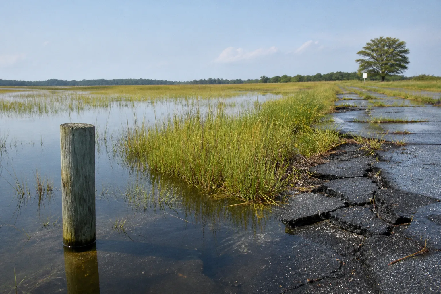
Salt marshes are not fixed strips of land along the water; as seas rise and the ground slowly sinks, wetlands can move inland, sometimes replacing low-lying forests and agricultural fields.
This is the central challenge behind marsh migration in Somerset County, MD: the community is not only preparing for higher water along today’s shoreline. We are planning for a future in which the shoreline itself may be in a different place.
Maryland’s Eastern Shore is experiencing relative sea level rise at roughly three times the global average. That figure reflects two forces working together: rising seas and regional land subsidence, the gradual sinking of the land. The result is a faster-changing coastal landscape, with consequences for drainage, habitat, roads, farms, and the way our community thinks about development.
Why Somerset County’s marshes are moving inland
A tidal marsh survives by staying close to the rhythm of the tides. Plants adapted to saltwater and periodic flooding grow across a low, muddy landscape that builds and shifts over time. When sediment and plant material allow the marsh surface to rise along with the water, the wetland can remain in place. When water levels rise faster than the marsh can build elevation, flooding becomes more frequent and the marsh begins to change.
That change can happen at the marsh edge, but it is not limited to the visible shoreline. Higher tides can push saltwater farther inland through creeks, drainage channels, and low areas in the landscape. Freshwater plants may struggle where salt levels increase. Forests can become stressed by repeated saltwater exposure and saturated soils. Farmland that once drained adequately may experience longer periods of standing water.
This is what sea level rise marsh migration looks like on the ground: not necessarily one dramatic event, but a gradual adjustment of the boundary between open water, marsh, forest, and working land.
Several conditions make Somerset County especially sensitive:
- Low coastal elevations: Much of the Eastern Shore landscape is flat, so a relatively small change in water level can affect a broad inland area.
- Land subsidence: The land is sinking while the sea is rising, increasing the local rate of relative sea level rise.
- Tidal creek networks: Water can travel inland through natural channels, carrying tidal influence beyond the open shoreline.
- A working rural landscape: Wetlands, forests, farms, roads, homes, and drainage systems often sit close together, so one landscape change can affect several community needs at once.
- Critical habitat: Salt marshes support birds and other wildlife, including the endangered Saltmarsh Sparrow, which depends on healthy tidal wetland habitat.
For residents, the practical question is not simply whether marshes are expanding. It is what that expansion means for your block, your access road, the drainage around your property, or the future use of nearby land.
Marsh migration is not the shoreline disappearing overnight; it is the shoreline being redrawn by water, land, plants, and time.
The mechanics of coastal retreat in Somerset County
The phrase “coastal retreat” can suggest a sudden loss of land, but marsh migration is more often a process of transition. A marsh may advance inland where conditions allow, while eroding or drowning at another edge. The overall wetland footprint can shift even when individual sections are shrinking.
The movement depends on the relationship between water levels, land elevation, sediment, vegetation, and human infrastructure. A marsh with room to move inland may gradually occupy areas that were once forest or farmland. A marsh blocked by a road, building, hardened shoreline, or other barrier may have nowhere to go. In that case, the wetland can become squeezed between rising water and fixed development.
This is sometimes called “coastal squeeze.” The term is useful because it explains why simply building a barrier along the water does not solve every problem. A shoreline structure may protect one property or road segment while preventing the marsh behind it from migrating naturally. Over time, the community may be left with less wetland, less habitat, and fewer natural buffers against storm surge.
That does not mean every shoreline structure is inappropriate. Roads, homes, public facilities, and critical infrastructure may require protection. But the decision has to account for the whole coastal system rather than treating each parcel as an isolated site. A solution that appears effective at one property line can shift water, erosion, or habitat pressure somewhere else.
In Somerset County, resilience planning therefore has to connect several questions:
1. Where is water already collecting or flooding more often?
2. Which marshes have enough inland space to migrate?
3. Which forests and agricultural areas are likely to experience increasing tidal influence?
4. Which roads, drainage features, and public facilities could become difficult to maintain?
5. Where can restoration support both habitat and flood resilience?
6. Which lands may need to be acquired or protected before development closes off future migration routes?
These are land-use questions as much as environmental questions. They belong in comprehensive planning, transportation planning, public works decisions, conservation programs, and neighborhood conversations.
How SLAMM helps planners look ahead
It is difficult to plan for marsh migration by looking only at current maps. A shoreline map tells us where wetlands are now, but not how they may respond under different future conditions. That is where predictive modeling becomes useful.
Maryland agencies use the Sea Level Affecting Marshes Model, commonly called SLAMM, to evaluate how wetlands may migrate and how land distribution could change under projected sea level rise scenarios. The model examines projected conditions for time horizons including 2050 and 2100.
SLAMM is not a crystal ball, and it does not tell a landowner that a particular field will definitely become open water on a particular date. Instead, it helps planners understand patterns and possibilities. It can show where low-lying wetlands may expand, where marshes may be lost, and where forests, fields, or developed areas may face increasing exposure.
State modeling has included a projected sea level rise of approximately 1.04 meters—about 2.7 to 3.4 feet—by 2100, depending on the scenario and assumptions used. The range matters because long-term planning should not be built around one supposedly certain future. Infrastructure that lasts for decades needs to be considered against multiple conditions, including more frequent flooding and greater tidal reach.
For our community, the value of a model is not the map alone. The value is the conversation the map makes possible.
A county or municipality can use modeled information to ask:
- Should a proposed road alignment remain in its current location?
- Does a drainage improvement need to accommodate future tidal influence?
- Is a conservation purchase more valuable if it creates room for marsh migration?
- Could a new development block an inland wetland pathway?
- Which public facilities need an adaptation plan rather than a one-time repair?
- Where should future growth be directed so that it does not add pressure to vulnerable land?
A model can also help prevent a common planning mistake: waiting for repeated damage before acknowledging the trend. If a road floods today only during unusually severe storms, it may still be part of a future transportation problem if sea levels continue to rise and the ground continues to subside.
Reading a future shoreline map carefully
When we look at a projected marsh map, it helps to keep three distinctions in mind.
First, a projected wetland area is not automatically a proposed acquisition area. Modeling identifies potential change; policy determines how the community responds.
Second, a projected change does not mean every parcel will experience the same outcome. Elevation, drainage, soil conditions, vegetation, tidal connections, and nearby infrastructure all matter.
Third, a map should be used to start local discussion, not end it. Residents often know details that a regional model cannot capture: a ditch that stays wet for weeks, a road that floods before nearby fields, a culvert that backs up during high tides, or a wooded area where saltwater damage has become visible.
That local knowledge is part of the planning record. It helps public agencies connect broad projections with what this means for your block.
Restoration that works with the marsh
Adaptation does not always begin with a wall, pump, or elevated road. In many cases, the most effective work is restoring the marsh’s ability to function as a marsh.
One technique used in Somerset County is the installation of runnels. These are shallow channels dug across the marsh surface to help drain trapped tidal water into nearby creeks. When water remains ponded on the marsh for too long, vegetation can die back and the surface can erode. Runnels provide a path for that water to leave, helping restore healthier wetland conditions.
The technique is modest in scale, but the principle is important: a marsh often needs its natural or historic drainage patterns restored before it can respond well to changing tides. Runnels are not a universal answer, and they do not eliminate sea level rise. They are one tool within a larger restoration strategy.
A practical coastal resilience program may combine:
- Runnels and drainage restoration to reduce trapped water on the marsh surface.
- Protection of inland migration corridors so wetlands have room to shift.
- Land acquisition in areas that are important for future habitat continuity.
- Monitoring to determine whether restoration improves vegetation, water movement, and wildlife use.
- Careful shoreline management that considers erosion, habitat, neighboring properties, and long-term marsh movement.
- Coordination with transportation and public works so roads and drainage projects do not unintentionally block wetland migration.
The monitoring piece deserves particular attention. Restoration is not finished when earth is moved or a channel is dug. The community needs to know whether the marsh is draining more effectively, whether native vegetation is returning, whether erosion has slowed, and whether the intervention is helping the species that depend on the habitat.
At Irish Grove Sanctuary in Somerset County, Audubon Mid-Atlantic received more than $610,000 to monitor tidal salt marsh restoration across 73 acres. The work is connected to protecting the endangered Saltmarsh Sparrow, a species whose future depends on the condition of tidal marsh habitat. The project illustrates why restoration is both an ecological and a planning issue: healthy marshes provide habitat, store water, reduce wave energy, and preserve a living part of the county’s coastal fabric.
The strongest coastal resilience projects do not ask the marsh to behave like a road or a seawall; they give the wetland enough room and function to keep doing its job.
The Marshes for Tomorrow goal
Individual restoration sites matter, but marsh migration is larger than any one sanctuary or shoreline parcel. Wetlands function as connected systems, and birds and other wildlife need enough habitat across the landscape to survive changing conditions.
The Marshes for Tomorrow initiative aims to identify and maintain 25,000 acres of long-term salt marsh habitat across Maryland’s Eastern Shore. Its focus includes conserving habitat for threatened bird populations and supporting a broader strategy for keeping salt marshes present as conditions change.
For Somerset County, a goal at that scale changes the way we think about conservation. The question is not only which marsh is most valuable today. It is also which lands may become valuable as future marsh habitat, which areas connect existing wetlands, and which locations can provide room for migration without creating unnecessary conflict with homes, farms, and public infrastructure.
That kind of planning requires patience. Conservation priorities may include land that does not look like a marsh now but could become part of the wetland system later. A forested edge, a low agricultural field, or a drainage corridor may be important because it gives the marsh somewhere to move.
It also requires transparent communication. Property owners deserve to understand why a particular area appears in a conservation plan, what the plan does and does not mean, and whether participation is voluntary or connected to a regulatory process. Residents should be able to see how habitat goals relate to flooding, public access, drainage, and the future of nearby roads.
A conservation target is most useful when it becomes locally understandable. Twenty-five thousand acres is a statewide Eastern Shore goal, but community members experience the issue at the scale of a creek, road, farm edge, or neighborhood. Public meetings and planning documents should make that connection clear.
Working farms, wetlands, and the future of low-lying land
One of the hardest parts of marsh migration planning is balancing environmental change with the needs of people who live and work on the land. Somerset County’s rural landscape is not empty space waiting for a future shoreline. It includes farms, homes, businesses, public roads, drainage systems, and family histories.
As marshes move inland, not every agricultural field will be inundated or converted to open water within the next decade. That would be an inaccurate and unnecessarily alarming conclusion. The more useful point is that some low-lying lands may face increasing water and salinity pressure over time, while other areas may remain suitable for farming or development for much longer.
Planning should distinguish among those conditions rather than treating the entire county as equally vulnerable.
For agricultural landowners, the relevant concerns may include:
- whether fields drain reliably after heavy rain;
- whether tidal water is reaching ditches or drainage outlets more often;
- whether salt exposure is affecting soils or vegetation;
- whether access roads remain dependable;
- whether conservation programs offer options for land that is becoming difficult to farm;
- and whether future planning decisions could limit adaptation choices.
For local governments, the concern is often how to make public investments wisely. Maintaining every road in its current location may not be practical if the surrounding landscape is changing. At the same time, abandoning or elevating a road affects emergency access, school transportation, farm operations, and daily travel. The appropriate response may differ from one segment to another, and there is no single countywide answer.
That is why comprehensive planning matters. It can establish a framework before individual crises force rushed decisions. A plan can identify vulnerable areas, protect future migration corridors, coordinate transportation and conservation priorities, and create a public process for discussing difficult tradeoffs.
Keeping development from closing off future options
New development can either support resilience or make it harder. A project located on higher, better-drained land may reduce long-term exposure. A project placed in a low-lying migration corridor may create future costs for residents and public agencies, particularly if it requires new roads, drainage systems, or protective structures.
The planning question is not simply whether a parcel can be developed under today’s conditions. It is whether development will remain safe, serviceable, and compatible with the landscape under tomorrow’s conditions.
That calls for a more complete review of:
- projected wetland migration;
- access during flooding;
- drainage capacity and outfall conditions;
- impacts on tidal creeks and adjacent marshes;
- the long-term cost of maintaining public infrastructure;
- and whether the proposal would block a natural inland pathway for wetlands.
Residents participating in a planning or zoning meeting do not need to speak in technical language to raise these issues. A clear question about future drainage, emergency access, or the effect on a nearby marsh corridor can be more useful than a broad argument about development in general.
What residents can do with this information
Marsh migration can feel like a subject reserved for scientists, engineers, or planning staff. It is not. The decisions that shape coastal resilience are made through public plans, capital budgets, zoning discussions, conservation programs, transportation studies, and restoration projects. Residents have a role in each of those conversations.
When navigating the board or attending a public meeting, start with the place you know. Ask how a proposed decision relates to the road, creek, field, or wetland near you. Then connect that local observation to the larger planning issue.
Useful questions include:
1. What future water conditions were considered?
A project designed only for current flooding may not perform well over its full lifespan.
2. Does the project leave room for marsh migration?
If wetlands are expected to move inland, ask whether the proposal blocks that path.
3. How will drainage work during high tides?
A ditch or pipe that drains well under ordinary conditions may behave differently when the receiving creek is already elevated.
4. What happens to access if the road floods?
Consider emergency vehicles, school buses, agricultural equipment, and residents who depend on the route every day.
5. How will success be measured?
For restoration, ask whether agencies will monitor vegetation, water movement, erosion, habitat, and maintenance needs.
6. Who is responsible for the long-term cost?
A short-term construction decision can create decades of maintenance obligations for a municipality or county.
7. What alternatives were considered?
Protection, relocation, restoration, acquisition, and managed transition can have different consequences for people and habitat.
These questions are not adversarial. They are part of responsible community development. Public participation works best when residents and agencies are trying to understand the same landscape from different positions.
Planning for a shoreline that will not stand still
The future of Somerset County’s wetlands will not be determined by sea level rise alone. It will also be shaped by where we build, what we protect, how we maintain roads and drainage, which restoration projects we monitor, and whether we preserve enough room for marshes to move.
The science gives us a clear reason to plan ahead: relative sea level rise on Maryland’s Eastern Shore is occurring at roughly three times the global average, and state modeling projects substantial additional rise by 2100. The community response, however, must remain grounded in local realities. A model cannot decide how a farm should be used, whether a road should be elevated, or which conservation approach will work best for a particular neighborhood. Those decisions require public discussion and careful attention to place.
Marsh migration in Somerset County, MD is not only an environmental story. It is a story about infrastructure, land use, biodiversity, public spending, and the community fabric we want to carry forward.
If we plan only for the shoreline we see today, we risk locking future residents into expensive and limited choices. If we plan for wetlands that can move, roads that can adapt, and land uses that respect changing water conditions, we give Somerset County more room to remain both resilient and livable.