Salt marsh migration: how it works on the Eastern Shore
A field can remain productive for years and then begin changing faster than a property map can keep up.
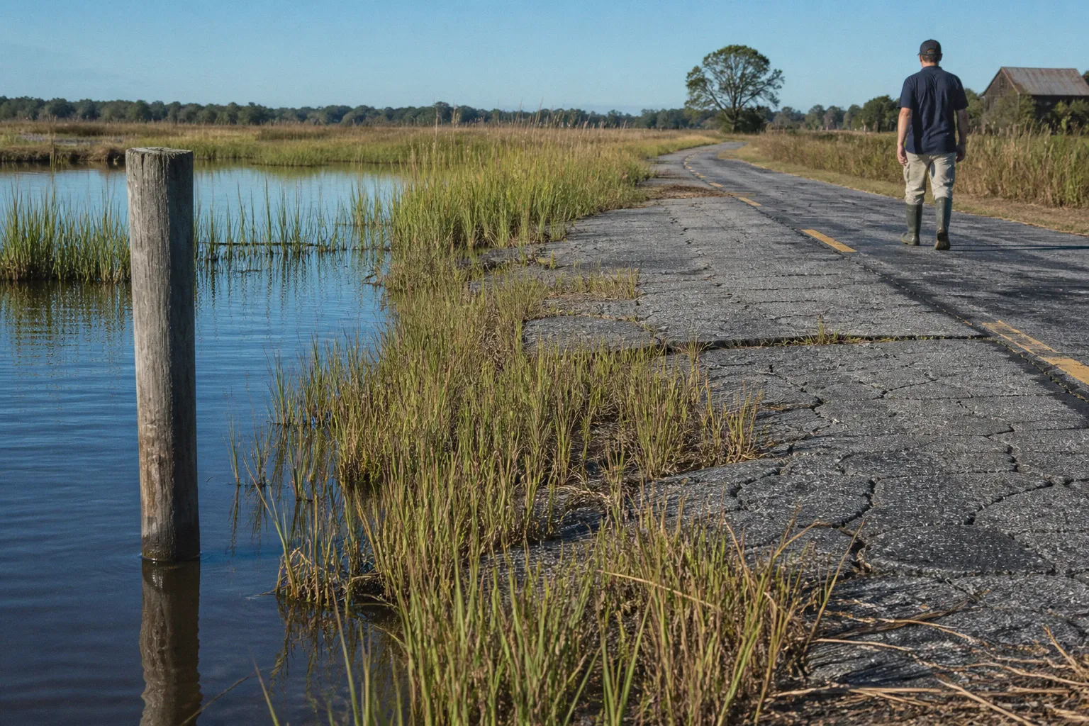
Ditches hold saltwater longer after a storm, drainage becomes less reliable, familiar crops struggle, and patches of marsh grass appear where corn or soybeans once grew. For residents and landowners in Somerset County, this is not an abstract climate story. It is a question of what happens to a farm, a road, a woodland edge, or a neighborhood when the shoreline starts moving inland.
Salt marsh migration is the process by which tidal wetlands expand into higher ground as sea levels rise. On Maryland’s Eastern Shore, that shift is being accelerated by two forces working together: the ocean is rising, and the Delmarva Peninsula is gradually sinking. The result is a particularly fast rate of relative sea level rise—about three times the global average.
That does not mean every field will become open water, or that every forest will change at the same pace. It does mean our community needs a more precise way to understand the landscape ahead, especially when planning drainage, roads, conservation, farming, and coastal resilience.
What is salt marsh migration?
A salt marsh is a coastal wetland regularly influenced by tides. It may look like a broad grassy plain, but it performs several jobs at once: it stores floodwater, slows storm surge, provides nursery habitat for fish and birds, captures carbon, and filters pollutants before they reach the Chesapeake Bay.
Salt marsh migration begins when rising water levels allow tidal flooding to reach areas that were previously only occasionally wet. As saltwater moves farther inland, soils become saltier, drainage patterns change, and plants that cannot tolerate salt begin to decline. Salt-tolerant marsh grasses then colonize the newly suitable ground.
In a stable coastal system, marshes can sometimes move inland naturally. The wetland edge advances while the outer edge erodes or becomes permanently submerged, allowing the marsh to maintain itself as the shoreline changes. But this movement depends on having somewhere to go. Roads, bulkheads, development, drainage channels, and other hard barriers can block that path. This is often called coastal squeeze: the marsh is pressed between rising water on one side and fixed infrastructure on the other.
For Somerset County, the most important distinction is that marsh migration is not simply “the ocean taking land.” It is a landscape transition with several possible stages:
1. More frequent tidal flooding reaches low-lying upland areas.
2. Soil salinity increases, sometimes before the vegetation visibly changes.
3. Salt-sensitive crops and trees lose vigor or fail to regenerate.
4. Wetland plants establish in depressions, field edges, and forest openings.
5. The former upland becomes transitional wetland, salt marsh, or open water depending on elevation, drainage, and storm exposure.
The pace varies from one property to the next. Agricultural land can transition nearly twice as fast as forested land because tilled fields and drainage systems often provide fewer obstacles to flooding and plant movement. That is why two neighboring parcels may show very different results even when they face the same bay or creek.
Salt marsh migration is not a single event. It is a series of changes in water, soil, plants, and land use that gradually redraws the working landscape.
Why the Eastern Shore is changing so quickly
Sea level rise is only part of the story. The Eastern Shore is also affected by land subsidence, the gradual sinking of the ground. Some of that sinking reflects the region’s long geological history; additional factors can include the settling of sediments and the loss of groundwater pressure. When rising water and sinking land occur together, the local experience is relative sea level rise—the amount of water gaining height compared with the ground beneath it.
On the Delmarva Peninsula, relative sea level rise is occurring at approximately three times the global average. That regional number helps explain why residents may see impacts sooner than a global average would suggest. A small change in elevation can determine whether a field drains after a storm, whether a tidal creek reaches a ditch, or whether a road remains passable during a high-water event.
The transition is already measurable. Between 1984 and 2022, about 25,000 acres of farmland in the Chesapeake and Delaware Bay watersheds were lost to sea level rise and marsh migration. In Somerset County alone, approximately 6.1 square kilometers—about 1,500 acres—of uplands transitioned to wetlands and open water between 2009 and 2017. That represented roughly 2% of the county’s agricultural land during that period.
Those numbers should not be read as a prediction that 2% of farmland will disappear every eight years. Rates are uneven, and local conditions matter. Still, they show that coastal wetland migration is not only a future planning concern. It is already affecting the county’s land base.
Elevation matters more than a simple shoreline map
A parcel does not have to touch the open bay to be vulnerable. Low ground connected to tidal creeks, drainage ditches, marshes, and flood pathways can experience saltwater intrusion well inland. In some locations, groundwater and shallow subsurface flows carry salt beyond the visible edge of a wetland.
When we look at what this means for your block, a few local details often matter more than a countywide label:
- Is the property connected to a tidal creek or drainage network?
- Does water remain in the field after ordinary high tides or only after major storms?
- Are there berms, roads, ditches, or culverts that redirect water?
- Does the ground rise gradually, giving marsh plants room to move inland?
- Is new development occupying the higher land where the marsh would otherwise migrate?
- Are nearby forests showing dead or thinning trees along their wetland edge?
This is why coastal resilience planning cannot rely on a single line drawn on a map. The practical question is not simply where the marsh is today. It is where the marsh has room to move, how quickly that movement may occur, and what infrastructure sits in its path.
Farmland, salinity, and the limits of adaptation
For farmers, saltwater intrusion can make a field unproductive before the land looks like a marsh. Corn and soybeans are especially sensitive to salt. Their approximate salinity thresholds are about 0.9 parts per thousand for corn and 2.7 parts per thousand for soybeans. By comparison, native warm-season marsh grasses can tolerate salinity levels up to roughly 20 parts per thousand.
That difference explains why a field may lose its agricultural value while still supporting vigorous plant growth. The land is not necessarily barren; it may be shifting toward a different ecological system.
Loblolly pines occupy an intermediate position, tolerating salinity up to approximately 5 parts per thousand. Even so, repeated flooding and salt exposure can prevent young trees from regenerating. Mature trees may stand for years after conditions have changed, creating the appearance of a healthy forest until the canopy begins to thin.
The practical choices for a salt-affected farm are not equally available everywhere. A landowner might consider altered cropping, improved drainage, temporary fallowing, conservation, or a transition to wetland habitat. But measures that work for a short period do not necessarily restore the old conditions. Local farmers have found that soil amendments such as gypsum are not a simple solution to saltwater intrusion, and we should be cautious about presenting them as one.
The question becomes economic as well as environmental. If crop yields decline, drainage costs rise, and flooding becomes more frequent, at what point does continued cultivation make less sense than enrolling the land in a conservation program? There is no single answer for Somerset County because the calculation depends on soil, access, acreage, equipment, crop history, tax considerations, and the owner’s long-term plans.
A useful way to compare land-use paths
| Land-use path | What it can offer | What it cannot solve |
|---|---|---|
| Continue conventional cropping | Keeps the field in production while conditions allow | Does not remove salt from repeated tidal flooding or guarantee stable yields |
| Modify drainage or field practices | May reduce standing water in some locations | Can redirect water, affect neighboring parcels, or become less effective as water levels rise |
| Restore transitional wetland | Creates habitat, stores floodwater, and may reduce maintenance pressure | Requires planning, suitable hydrology, and acceptance that the land use is changing |
| Enroll in a conservation easement | Can provide financial support and protect land from future development | Does not return the property to its former agricultural condition |
| Hold land without a plan | Delays an immediate decision | Leaves invasive plants, erosion, and infrastructure risks unmanaged |
One established option is a wetland conservation easement through programs such as those administered by the U.S. Department of Agriculture’s Natural Resources Conservation Service. On Maryland’s Eastern Shore, eligible farmers may receive up to $4,000 per acre to transition salt-damaged, unproductive cropland into protected salt marsh.
That kind of payment does not make every parcel financially whole, and eligibility rules matter. But it changes the conversation. Conservation is not necessarily a choice between doing nothing and giving land away. It can be a planned land-use decision that recognizes the ecological and economic value of a property after farming becomes unreliable.
Ghost forests show the transition in real time
One of the clearest signs of saltwater intrusion is the appearance of a ghost forest. The phrase describes a stand of mature trees that have died because saltwater has entered the soil or flooded the root zone, while the trunks remain standing.
Across a four-county area of Maryland’s Eastern Shore, state surveys over the past decade identified more than 400,000 forested acres newly affected by saltwater. These forests may not disappear all at once. First, low-lying trees may decline. Then the understory changes, seedlings fail to establish, and open gaps widen. Eventually, the standing dead trees give the area its ghostly appearance.
The process can be especially confusing for residents because the forest may look intact from a road or aerial photograph. Tree death and marsh establishment do not always happen on the same schedule. A woodland edge may remain in transition for years, with dead trunks, wet ground, shrubs, and patches of marsh grass occupying the same area.
This transition has consequences beyond appearance:
- Dead trees can create hazards near roads, trails, and utility corridors.
- Loss of tree cover changes shade, wind exposure, and local habitat.
- Bare or disturbed ground can be more vulnerable to erosion.
- The disappearance of forest vegetation may alter carbon storage.
- New wetlands can provide flood-buffering and wildlife benefits if they remain connected to the broader marsh system.
It is tempting to describe ghost forests only as a sign of ecological loss. That misses half the picture. The death of an upland forest is a serious change, but the wetland that follows may provide valuable storm protection and habitat. Our planning challenge is to acknowledge the loss without overlooking the resilience emerging in its place.
Phragmites can block a healthier transition
The invasive grass Phragmites australis is one of the major complications. Phragmites can form dense stands that outcompete native marsh plants and create a wall along migration corridors. Instead of allowing a diverse marsh community to move inland, the invasive grass can dominate disturbed ground and reduce habitat quality.
That makes monitoring and control part of coastal resilience. A parcel does not become ecologically healthy simply because it is wet. The species composition matters, as do tidal connections, open-water areas, nesting habitat, and the ability of native plants to establish.
For landowners and local governments, the most useful approach is usually early identification rather than waiting until a dense stand has taken over. Management can involve site assessment, coordinated treatment, follow-up monitoring, and attention to how control work affects nearby wetlands. Because water moves across property boundaries, isolated action may have limited results if adjacent parcels remain unmanaged.
This is also where navigating the board—whether a county planning body, municipal council, soil conservation office, or environmental agency—becomes part of practical land stewardship. Residents do not need to arrive with a technical report in hand. A clear description of what is changing, when flooding occurs, and which properties or public facilities may be affected gives local staff a place to begin.
Conservation easements can turn difficult land into a resilience asset
When farmland is repeatedly damaged by salt, the most responsible decision may not be to force it back into production. A conservation easement can preserve the land as open space while allowing it to transition into wetlands that support the wider watershed.
This matters at the property level, but it also matters at the scale of the community. A connected marsh can absorb and slow water more effectively than a collection of isolated wet patches. It can provide room for floodwaters, reduce pressure on downstream drainage systems, and support fish and wildlife moving through the Chesapeake Bay watershed.
A well-designed easement may also help avoid future conflicts. If a parcel is likely to become wetland, placing roads, septic systems, buildings, or other fixed infrastructure there can create costs for the next generation. Conservation can keep the land available for ecological functions rather than locking the community into expensive protection or repeated repair.
That does not mean every low-lying parcel should be converted immediately. We need to distinguish between land that can remain productive with reasonable adaptation and land where repeated salt damage is already signaling a more fundamental shift. The best decisions use field observations, elevation data, soil and water information, and the owner’s goals together.
For a landowner beginning that conversation, the following sequence is often more useful than jumping directly to a program application:
1. Document the change over time. Keep photographs, crop records, notes on tidal flooding, and dates when water remains in the field.
2. Map the water connection. Identify nearby creeks, ditches, culverts, low crossings, and areas where saltwater may enter.
3. Separate temporary storm damage from chronic intrusion. One unusually wet season does not tell the whole story, but repeated patterns do.
4. Ask for a site-specific assessment. County offices, conservation professionals, and relevant state or federal programs can clarify what the land is becoming.
5. Compare the full cost of continued farming. Include lost yield, drainage maintenance, equipment access, and the risk of future damage.
6. Consider the community fabric. A decision affecting one parcel may influence neighboring farms, roads, ditches, habitat corridors, and emergency access.
7. Review any easement carefully. Understand permitted uses, maintenance responsibilities, restrictions, payment terms, and long-term implications before signing.
This process keeps the conversation grounded. It also respects the fact that landowners are not merely managing acreage; they are making decisions about family history, income, identity, and the future shape of the county.
A conservation easement can be more than a retreat from farming. In the right place, it is an investment in a marsh’s ability to protect the land and people behind it.
Planning for a county where the marsh has more room to move
The long-term question is not whether Somerset County will experience wetland migration. The evidence shows that it is already happening. The question is whether our policies will guide that transition or react to it parcel by parcel after roads, farms, and homes are already at risk.
The Maryland Eastern Shore’s remaining salt marshes are part of that planning picture. An April 2026 report from Audubon Mid-Atlantic, Marshes for Tomorrow, outlines a landscape-scale restoration plan for Maryland’s remaining 172,000 acres of salt marsh. A landscape-scale approach matters because marshes do not follow municipal borders or property lines. Their movement depends on connected water, connected habitat, and enough undeveloped upland to accommodate change.
Under a three-foot sea level rise scenario, Maryland could lose up to 90% of its coastal marshes by 2100. That projection is not a timetable for every Somerset County neighborhood, but it makes one point plain: preserving today’s marsh without planning for tomorrow’s migration may not be enough. If the outer marsh drowns and no inland space is available, the county loses the wetland system rather than allowing it to relocate.
What county and municipal planning can do
A comprehensive plan can help translate this broad challenge into decisions that affect roads, development, public works, and conservation. Several actions are especially relevant:
- Identify migration corridors where marshes can move inland without being blocked by new construction.
- Direct development toward safer, better-served locations rather than extending infrastructure into low-lying areas.
- Coordinate drainage and stormwater planning so that one project does not increase flooding on another property.
- Protect wetlands and forest transition zones through land-use tools and conservation partnerships.
- Use updated flood and elevation information when evaluating roads, bridges, culverts, and public facilities.
- Plan for changing maintenance needs, including the future condition of roads and drainage systems exposed to saltwater.
- Make public participation accessible, with clear notices, maps, meeting times, and explanations of how comments affect decisions.
That final point is easy to underestimate. A resident who receives a notice about a development, drainage project, or zoning change may not know whether the decision has anything to do with coastal resilience. The connection may be indirect but important. A new road can block marsh movement. A filled wetland can push water toward neighboring properties. A subdivision can increase the maintenance burden on a drainage system that is already under stress.
When you attend a public meeting, ask questions that connect the proposal to the physical landscape:
- How will this project change where stormwater goes?
- Does the site overlap a potential marsh migration area?
- What happens to access during high tides or major storms?
- Who will maintain the drainage or road infrastructure over time?
- Has saltwater exposure been considered for materials, plants, and utilities?
- Could this decision limit future options for the surrounding community?
These are not adversarial questions. They are practical questions about whether a project fits the place where it is being built.
A more useful definition of coastal resilience
Coastal resilience is sometimes treated as a choice between holding the shoreline in place and abandoning vulnerable land. Salt marsh migration gives us a broader set of options. We can preserve critical infrastructure where it is needed, avoid putting new assets in predictable pathways, support farmers facing genuine losses, and give wetlands room to perform the work that hard infrastructure cannot do alone.
That approach requires patience because the changes are gradual and uneven. It also requires honesty. Some land will no longer support the use it supported in the past. Some roads will need redesign or relocation. Some forests will become wetlands. Pretending otherwise only makes the eventual choices more expensive.
At the same time, the future is not defined only by loss. A marsh that is allowed to migrate can buffer storm surge, store carbon, filter water, and maintain habitat as the shoreline changes. A protected transition zone can become a community asset rather than an unmanaged liability. A farmer who receives fair support for retiring salt-damaged ground may be making a forward-looking decision, not giving up.
For Somerset County, the strongest response will connect private land decisions with public planning. That means treating farms, marshes, forests, roads, drainage systems, and neighborhoods as parts of one living landscape. It means making the science understandable enough for residents to use and the planning process open enough for local knowledge to matter.
Salt marsh migration on Maryland’s Eastern Shore is already redrawing the map. Our job is to make sure the new map still has room for safe homes, working farms, healthy watersheds, accessible roads, and a resilient community fabric.