Living shoreline failures: correcting design errors
The ledger does not lie. Three years after a property owner along Somerset County’s tidal creeks spends tens of thousands of dollars on Spartina alterniflora plugs and a coconut-fiber log, the…
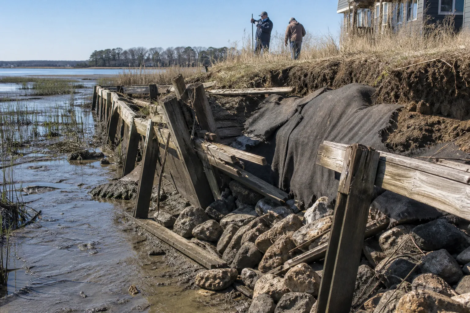
The ledger does not lie. Three years after a property owner along Somerset County’s tidal creeks spends tens of thousands of dollars on Spartina alterniflora plugs and a coconut-fiber log, the surveyor may return to find half the planted marsh gone, the toe material displaced, and the coir log somewhere down the cove.
The planting did not necessarily fail because the grass was wrong. More often, the design failed before the contractor arrived: the wave energy was never properly assessed, the elevation was misread, or a containment feature was installed where a wave-attenuation structure was required. The result is expensive in every direction—dead plants, scoured substrate, sediment loss, a second round of engineering, and a permit file that now has to explain why the original design did not hold.
The physical scale of the problem matters. Maryland loses an estimated 260 acres of tidal shoreline every year to erosion, and that erosion carries roughly 4.7 million cubic yards of sediment into the Chesapeake Bay annually. Around 70 percent of Maryland’s Chesapeake Bay shoreline is actively eroding, while roughly 85 percent is privately owned. Most failed living shorelines, then, are not failed public works projects. They are somebody’s backyard, somebody’s tax bill, and somebody’s permit record.
That is why correcting a failed shoreline begins with the physics, not the plant list.
The Physics of Failure: Why Native Plantings Often Wash Away
Spartina alterniflora and Spartina patens are resilient native marsh plants. They stabilize sediment, slow shallow water, and contribute to the gradual formation of a functioning marsh edge. But neither species is armor. They are rooted plants growing in material that can scour when moving water and waves exert more force than the substrate and root mat can withstand.
A common failure sequence on an exposed site looks like this:
1. A contractor installs a coconut-fiber log near the mean-tide line.
2. Native plugs are planted landward of the log.
3. A major storm produces waves larger than the system was designed to absorb.
4. Water scours around the log because it is not adequately anchored, is too low, or does not extend far enough across the exposed section.
5. Plugs lose their substrate, become buried by displaced sediment, or float out with the root zone.
6. The coir material unravels or migrates landward.
7. Sediment moves into adjacent shallow-water habitat, potentially affecting submerged aquatic vegetation.
That is not simply a planting failure. It is a design failure. The vegetation did what it was supposed to do—develop roots and trap sediment—until the hydraulic forces exceeded what the root structure and the containment feature could dissipate.
The same distinction applies to elevation. A marsh that sits below mean high water is not automatically doomed, and a marsh planted above that datum is not automatically secure. Spartina alterniflora, the smooth cordgrass associated with the low marsh, commonly occupies lower tidal elevations and can tolerate frequent inundation. Spartina patens, often called salt hay, is generally associated with the higher marsh and with less frequent flooding. The relevant question is not whether the entire planting area is below mean high water. It is whether each species is placed within an elevation and inundation range it can tolerate at that particular site.
That range changes with salinity, tidal exchange, creek geometry, sediment type, and the way the shoreline transitions into the upland. A planting plan that treats the marsh as one flat strip is already missing the biological gradient.
The right grass in the wrong elevation is still the wrong design. Plants can tolerate water; they cannot negotiate with a missing substrate.
A failed shoreline may therefore have several overlapping causes:
- The plants were installed at the wrong tidal elevation.
- The root zone was placed in loose or recently disturbed sediment.
- The toe was exposed to waves beyond the capacity of a coir log.
- A stone sill was undersized or set at the wrong depth.
- The design ignored drainage from the bank behind the marsh.
- The planting window, salinity conditions, or early maintenance were unsuitable.
- The site was treated as a garden bed when it needed a hydraulic system.
The correction depends on identifying which of those mechanisms actually occurred. Replanting without that diagnosis is just repeating the original expense.
Matching Vegetation to Energy: Fetch and Depth Requirements
Fetch is the unobstructed distance across water over which wind can generate waves before those waves reach the shoreline. It is not the only factor in shoreline design, but it is one of the most consequential. A short, sheltered creek bend and an open reach exposed to a long wind path may be only a few miles apart and may require entirely different stabilization approaches.
Depth matters as well. A feature placed in shallow water may function as a planted edge or low containment structure. The same feature placed several feet deeper is exposed to greater wave action and may need to be designed as a structural element. The difference is not cosmetic. It changes the stone size, footprint, anchoring, construction access, permit drawings, and project cost.
A practical design conversation should consider the relationship among fetch, depth, shoreline orientation, tidal range, substrate, and the presence of existing marsh. A table can help frame the issue, but it cannot replace a site-specific assessment:
| Parameter | Lower-energy setting | Moderate-energy setting | Higher-energy setting |
|---|---|---|---|
| Fetch | Short and substantially sheltered | Meaningful open-water exposure | Long open-water exposure or repeated storm-wave attack |
| Water depth at the proposed toe | Shallow enough for a planted or low-containment edge | Deep enough that the toe must resist regular wave action | Deep or exposed enough to require a deliberately engineered wave-attenuation structure |
| Likely treatment | Marsh planting with careful grading and substrate preparation | Hybrid treatment using marsh vegetation with a coir or stone toe as appropriate | Marsh fringe behind a properly designed sill, breakwater, or other structural feature |
| Role of vegetation | Primary stabilizing element | One part of the stabilization system | Ecological and transitional element; not the sole defense |
| Risk of underbuilding | Plants may establish slowly or fail in patches | Toe scour and sediment loss are common failure modes | Rapid retreat, structural displacement, and repeated rework are possible |
Three field errors appear again and again.
Skipping the fetch measurement
Property owners often estimate exposure from the shoreline, while contractors estimate it from the dock or from a quick look at an aerial image. That is not enough. The relevant exposure is the wind-and-wave path toward the proposed work area, including the orientation of the shoreline and the amount of open water in the direction of prevailing storm winds.
A site on a narrow creek may still experience concentrated wave energy if the shoreline faces an open reach. Conversely, a site with a visually broad view may be protected by marsh islands, bends, or other obstructions. The design should be based on the actual geometry of the waterbody rather than on a generic “creekfront” label.
Ignoring depth at the proposed sill location
A low sill placed in shallow water is not the same design as a sill placed in deeper water. At greater depth, waves can reach the shoreline with more energy, and the structure must remain stable while allowing the system to retain its ecological function. The sill may need a wider base, larger stone, a different crest elevation, or a different alignment.
A drawing that simply labels a feature “stone sill” without showing the relevant elevations and water depths is not a complete explanation of how the system is expected to work.
Planting outside the biological gradient
The mistake here is not that all plants below mean high water will fail. The mistake is treating a tidal datum as a universal cutoff without considering species.
Spartina alterniflora is commonly suited to the lower marsh, including areas that are flooded frequently and may lie at or below mean high water depending on the local tidal frame and site conditions. Its placement should reflect the actual inundation pattern, salinity, and the elevation at which the root zone can remain stable.
Spartina patens generally belongs higher on the marsh platform, where flooding is less frequent and the ground is not persistently submerged. It may perform poorly if planted in the same low, wet zone intended for smooth cordgrass. At the same time, pushing S. alterniflora too far landward or placing S. patens at the water’s edge can create a different problem: the plants may be biologically appropriate to the region but mismatched to the elevation.
The correct approach is to design a transition rather than draw one uniform planting band. That transition may include low-marsh vegetation near the water, higher-marsh vegetation farther landward, and upland or bank-stabilizing plants above the regular tidal influence. The exact arrangement depends on the site survey and the existing shoreline profile.
This is one of the most important corrections for anyone researching Maryland living shoreline planting mistakes: species selection cannot be separated from tidal elevation. “Native” is not a substitute for “appropriate here.”
Beyond the Plants: Addressing Structural Scour and Wave Attenuation
This is where the boots-on-the-ground inspector parts ways with the standard erosion-control brochure. A living shoreline is not an ideological choice. It is a hydraulic design that uses living materials where they can function and structural measures where the site requires them.
When a site needs structural wave attenuation, the structure is not a betrayal of the living-shoreline approach. It is what allows the marsh to survive. A hybrid shoreline can reduce energy offshore, retain sediment at the toe, and create conditions in which vegetation can establish. Without that protection, the planting may be asked to perform a job it was never capable of doing.
Bulkheads create a different set of problems. They tend to reflect wave energy rather than dissipate it gradually. The reflected energy can scour the bottom immediately offshore and contribute to erosion along adjacent unarmored shorelines. A property owner may stabilize one lot while transferring more energy and sediment loss to the next lot downstream. In a densely developed shoreline, that is not a private solution; it is a change to the behavior of the entire edge.
The components of a functioning hybrid system may include:
- Stone sill: A low-profile rock structure set offshore or at the marsh toe. Its job is to reduce wave energy and help retain the substrate, not to act as a vertical wall. Its alignment, crest elevation, stone size, and foundation must respond to the site’s exposure and depth.
- Biolog or coir log: A cylindrical coconut-fiber roll that can contain sediment and protect young plantings in lower- to moderate-energy conditions. It is useful, but it is not a substitute for a structural sill on a high-energy shoreline.
- Offshore breakwater: A rock or reef-like feature placed farther from shore to absorb wave energy before it reaches the marsh edge. It may be appropriate where an inshore sill alone would be unstable or where the fetch produces repeated wave attack.
- Graded transition zone: The slope between the structural feature, marsh platform, and upland bank. An abrupt transition concentrates flow and creates a new scour point. A graded, vegetated transition spreads the change in elevation and gives sediment somewhere to settle.
- Bioengineering materials: Live plants and biodegradable materials integrated with structural elements. These can speed the transition from a construction site to a functioning marsh, but they still depend on stable substrate and suitable elevation.
On a failed installation, the visible symptom is often a missing plant bed. The actual failure may be offshore. The coir log has drifted, the toe has scoured, the bank has retreated, and the plants disappeared because the material beneath them was removed. In that case, another coir log is not a correction. It is a replacement of the symptom.
The corrective design may require removal of displaced material, reshaping of the bank, stabilization of the toe, and a new planting plan that reflects the revised profile. In some cases, the original materials can be incorporated into the repair. In others, they are too degraded, too far out of position, or too small for the exposure. The answer has to come from the failure mechanism rather than from what is easiest to order.
Navigating the Living Shorelines Protection Act for Remediation
Maryland’s Living Shorelines Protection Act, enacted in 2008, changed the starting point for shoreline stabilization. Before a property owner builds a hardened structure such as a bulkhead, riprap revetment, or solid seawall, the owner generally must demonstrate why a living shoreline is not feasible or would not adequately address the site conditions.
That is a permitting requirement, not an absolute prohibition on hardened structures. Hard stabilization remains possible where the site conditions justify it. But the application has to explain why a living or hybrid approach cannot succeed, or why the proposed structural component is necessary to make the living portion viable.
Remediation creates an additional complication. The applicant is no longer describing an empty shoreline. There is an existing installation, an existing failure, and an existing record of what was authorized or constructed. A revised application should connect those facts clearly.
The permit record typically needs to address:
1. The existing condition: Show the current bank geometry, remaining vegetation, displaced coir or stone, exposed substrate, and areas of sediment loss.
2. The hydraulic setting: Document fetch, water depth, shoreline orientation, tidal conditions, substrate, and the location of the proposed work relative to the existing marsh.
3. The failure mechanism: Explain whether the failure resulted from scour, wave energy, elevation, substrate instability, drainage, species mismatch, construction disturbance, or a combination of causes.
4. The revised design: Show how the new profile, sill, breakwater, toe treatment, or planting layout responds to that mechanism.
5. The living-shoreline component: Identify where vegetation remains feasible and which species are appropriate to the proposed tidal elevations.
6. The reason for any hardened element: If a hard structure is proposed, explain why it is necessary at that location and why a purely nonstructural treatment would not provide a stable or lawful solution.
The permit errors that create the most avoidable delays are usually not dramatic. They are gaps in the record.
- Insufficient site data: A plan that does not show relevant elevations, water depths, fetch, or the location of the original failure gives the reviewer no way to evaluate the design.
- No failure analysis: Saying that the previous installation failed does not explain why the replacement should work. The application must address the mechanism, not merely document the outcome.
- Inconsistent vegetation specifications: A plan may list native species but place them at elevations or salinity conditions they are unlikely to tolerate. Native status alone does not resolve the biological question.
- Unclear relationship to the existing permit: The revised work should identify what was approved, what was built, what remains, and what will change.
- Skipping Critical Area review: Much of Somerset County’s tidal waterfront falls within Maryland’s Chesapeake Bay Critical Area regulatory framework. That adds another layer of review and can affect the location, footprint, vegetation, and construction methods.
- Starting work before the revised authorization is clear: Moving equipment onto the site before the permit path is settled can turn a repair into an enforcement problem.
The permit process is slower and more expensive after a failure because the applicant has to explain the past as well as the future. That is still preferable to building the same unstable design a second time.
Corrective Strategies for Existing Erosion and Sediment Loss
A failed living shoreline is not automatically a lost cause. It is a shoreline with a documented failure mode, even if the documentation is incomplete. The repair begins by establishing what moved, where it moved, and what force moved it.
Step 1: Document the failure before disturbing the site
Photograph the current condition from fixed viewpoints. Record the location of the remaining plants, the position of the biolog, exposed roots, scour holes, sediment deposits, bank cracks, drainage outlets, and any areas where the shoreline has retreated.
The record should distinguish between a plant that died in place and a plant bed that was physically removed. Those are not the same failure. A dead planting may point to elevation, salinity, season, competition, or early maintenance. An absent planting with a scoured toe points toward a hydraulic or substrate problem.
If a survey is needed, it should capture the bank profile and relevant water elevations rather than relying on photographs alone. The permit reviewer will need to understand the existing grade before evaluating a new one.
Step 2: Re-evaluate the hydraulic environment
Fetch, depth, and substrate are central, but they should be considered alongside the shoreline’s orientation, wave approach, tidal exchange, existing marsh, and drainage from the upland.
Ask the questions the first design should have answered:
- From which direction do the largest waves approach?
- How much open water lies along that approach?
- At what depth is the proposed toe or sill located?
- Is the substrate cohesive enough to hold a planted root zone?
- Does runoff from the bank concentrate at one point?
- Is the shoreline retreating uniformly, or is scour concentrated around an outlet, corner, or structure?
- Did the original construction alter the slope or remove stabilizing vegetation?
- Is the proposed planting elevation consistent with the inundation tolerance of the selected species?
If the original design assumed a sheltered site and the actual shoreline is exposed to a long fetch, the design was wrong from the beginning. If the plants were placed in a lower tidal zone than they could tolerate, adding a sill may not solve the biological problem. The re-evaluation must separate those issues.
Step 3: Select the corrected design
For a lower-energy site where the primary problem was biological establishment, the repair may involve regrading, replacing lost substrate, correcting the planting elevation, and replanting. That is the simplest case, but it still requires care. Plants should not be installed into the same unstable zone merely because it is already cleared.
For a moderate-energy shoreline, the correction will often be hybrid. A coir log may remain useful for containment during establishment, but it should not be expected to absorb forces beyond its capacity. A properly sized stone sill, combined with a graded marsh platform and species placed according to tidal elevation, may be necessary.
For a higher-energy site, the structure carries the hydraulic load. Marsh vegetation can still be part of the design, but it functions behind or around the wave-attenuation feature. The marsh is the ecological finish and a contributor to long-term stability; it is not the sole foundation of a shoreline exposed to repeated high-energy waves.
The choice should also account for construction access. A design that works on paper may fail during installation if equipment access requires removing the very bank vegetation the project is intended to protect. Access routes, staging areas, temporary disturbance, and restoration of those areas belong in the design conversation.
Step 4: Replant by elevation, not by habit
The planting plan should show where low-marsh and high-marsh species belong in relation to the tidal frame. Spartina alterniflora is generally the species considered for the lower, more frequently inundated portion of the marsh. Spartina patens is generally better suited to the higher marsh, where flooding is less frequent and the substrate is not continuously waterlogged.
That does not mean every site can be divided by a universal line at mean high water. Local conditions matter. A bank may have a compressed transition, a broad intertidal platform, irregular microtopography, or a history of sediment deposition that changes the appropriate planting pattern. The plan should therefore use elevation, inundation frequency, salinity, and observed nearby vegetation together.
A good repair may include fewer species in the first phase than the finished marsh is expected to contain. The immediate goal is not botanical variety for its own sake. It is to establish vegetation where the plants can survive while the system retains sediment and develops a more complex marsh edge.
Step 5: Address maintenance expectations
Living shorelines are not maintenance-free. They need inspection after major storms, removal of accumulated debris, protection from avoidable disturbance, and replacement of gaps where plants fail to establish. A repaired site should be monitored for toe scour, bank settlement, displaced stone, damaged coir material, drainage erosion, and changes in the planting elevations.
Early maintenance is especially important because a young planting has not yet developed the root density of a mature marsh. A small gap can become a channel for concentrated flow. A piece of storm debris can pull apart a coir log. A minor settlement can leave the root zone too low and subject to longer inundation.
The property owner does not need to treat the shoreline like a manicured lawn. The point is to identify changes before a small repair becomes a second failure. That means knowing what the site looked like when the work was completed and making periodic comparisons afterward.
A living shoreline is a maintenance schedule, not a one-time project. The Bay keeps testing the design long after the contractor leaves.
Step 6: Verify the permit path before construction
A repair is still regulated work. The fact that a previous shoreline project was permitted does not automatically authorize a different sill, a larger footprint, a new revetment, or a change in planting elevation. The revised design should be reviewed against the applicable state and local requirements before equipment arrives.
If the site cannot support a fully nonstructural shoreline, the record should say why. If a hybrid design is feasible, the structural element should be described as part of that system rather than added as an afterthought. A half-built repair that fails during permit review is the worst of both worlds: the budget is depleted, the shoreline is disturbed, and there is no approved design on file.
The Bottom Line on Somerset County’s Failed Shorelines
The recurring mistake behind many failed installations is not a lack of enthusiasm for native plants. It is the decision to begin with the plant list and treat the water as background scenery.
The water is the design problem.
Measure the fetch. Establish the relevant elevations and depths. Understand the substrate and the direction of wave approach. Match Spartina alterniflora to the lower, more frequently flooded portion of the marsh where site conditions support it, and use Spartina patens higher on the marsh where its inundation tolerance is a better fit. Do not use mean high water as a blanket rule for every species, and do not use “native” as proof that a plant is correctly placed.
Then decide whether the site needs a planted edge, a coir containment feature, a stone sill, an offshore breakwater, or a combination of those elements. Build the structural part the site actually demands. Shape the transition so water does not concentrate at a new weak point. File the permit documentation before construction, including an honest explanation of why the first design failed.
For Somerset County property owners, that is the practical route to fixing failed living shorelines. The plants matter, but they are only one part of the system. If the energy is not addressed first, the planting is being asked to carry a hydraulic load it cannot carry. The result is predictable: erosion, sediment loss, repeated construction, and a second permit problem created by the first.
A living shoreline can be durable, but durability is designed into it. It comes from matching species to tidal elevation, structure to wave energy, and maintenance to the realities of a shoreline that never stops moving.