Critical Area Buffer Plants: How to Choose the Right Mix
Maryland’s Chesapeake Bay Critical Area regulations establish a 100-foot natural vegetation buffer measured landward from the mean high water line of tidal waters, tributary streams, and tidal wetlands.
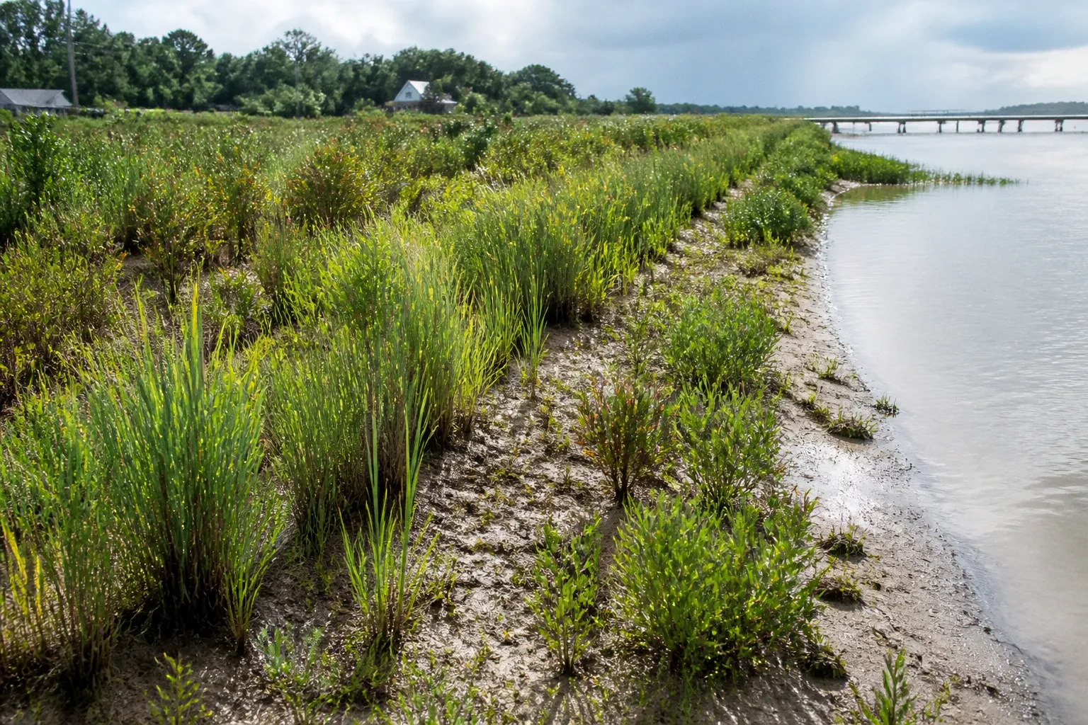
The broader Critical Area extends 1,000 feet from those tidal features. In Somerset County, that distinction determines whether a proposed clearing, shoreline repair, driveway, septic installation, or development activity requires buffer review and mitigation.
Plant selection is therefore not a landscaping preference. It is a component of statutory compliance. The selected species must be native to the Maryland Coastal Plain, suited to the site’s hydrology and salinity conditions, and arranged to satisfy applicable planting-density credits. Where vegetation is removed or restored, the property owner may also need an approved Buffer Management Plan.
For Somerset County property owners, the correct question is not which plants survive in a garden center. It is which native plant mix satisfies the buffer function, the crediting rules, and the applicable local approval process.
Understanding the 100-Foot Buffer Mandate in Somerset County
The Critical Area Buffer begins at the mean high water line and extends at least 100 feet inland. The measurement is not taken from a property boundary, an existing bulkhead, a lawn edge, or the visible limit of ordinary high water. It is tied to the regulatory shoreline or water feature identified during site review.
The 1,000-foot Critical Area boundary is broader. It includes land and water areas adjacent to tidal waterways, tributary streams, and tidal wetlands. The 100-foot buffer is a specific protected zone inside that larger area.
This produces three separate compliance questions:
- Is the parcel within the Maryland Critical Area?
- Does the proposed work enter or affect the 100-foot buffer?
- If vegetation is cleared, disturbed, or used as mitigation, what planting and management documents are required?
A parcel can be within the 1,000-foot Critical Area without every portion of the parcel being part of the 100-foot buffer. Conversely, a relatively narrow construction area can trigger detailed buffer review if it crosses the regulated line.
What the buffer is intended to do
A properly established buffer performs several regulatory and physical functions:
- It intercepts sediment before runoff reaches tidal water.
- It slows surface flow from roofs, driveways, lawns, and disturbed soil.
- It stabilizes streambanks and shoreline-adjacent ground.
- It supports root systems that reduce erosion.
- It provides habitat and shade.
- It limits direct human disturbance near sensitive waterways.
A grass-only lawn is not equivalent to a forested or shrub-dominated buffer. Mowed turf generally provides a shallow root system and limited vertical structure. A compliant restoration design must account for canopy, understory, shrub, and herbaceous layers where site conditions allow.
The buffer also cannot be treated as an unregulated planting strip. Vegetation clearing may require local planning or zoning approval, and the owner may need to submit a Buffer Management Plan. The plan type depends on the scope of the work.
The 100-foot buffer is a regulated land-use boundary, not a suggested setback for attractive landscaping.
The physical site controls the plant palette
Somerset County contains low-lying Eastern Shore landscapes with variable drainage, tidal influence, sandy or silty soils, seasonal saturation, and exposure to wind. A species that performs well on a dry upland lot may fail in a wet swale. A freshwater wetland plant may not tolerate brackish conditions. A salt-tolerant shrub may be unsuitable for an inland tributary buffer.
Before selecting plants, the site should be classified by physical conditions:
- Hydrology: dry, seasonally wet, permanently wet, or subject to tidal flooding.
- Salinity: non-tidal freshwater, brackish, or exposed to saltwater influence.
- Soil texture: sand, loam, silt, clay, or compacted fill.
- Slope: level, moderate, or steep enough to create concentrated runoff.
- Light exposure: full sun, filtered light, or shade beneath existing canopy.
- Erosion pattern: sheet flow, rills, bank undercutting, or localized scour.
- Existing vegetation: intact native cover, degraded lawn, invasive-dominated growth, or mixed forest edge.
This classification should precede any plant order. Otherwise, the owner risks installing a species mix that is technically native but functionally wrong for the site.
Navigating the Maryland Native Plant List for Coastal Plain Ecoregions
The Maryland Native Plants Program became effective on July 1, 2024, under 2023 legislation identified as HB950/SB836. The program introduced a Commercial Maryland Native Plant List covering approximately 650 species native to Maryland’s ecoregions.
For Somerset County projects, the relevant issue is not merely whether a plant is native somewhere in Maryland. The plant must be appropriate for the Coastal Plain setting and for the actual buffer conditions. Piedmont or Mountain species should not be treated as automatically suitable for Somerset’s wetland, shoreline, or salinity-exposed sites.
The list should be used as a starting point for species verification. It does not replace a site assessment.
Select plants by functional layer
A buffer planting plan normally becomes more resilient when it includes multiple vegetation layers. The exact composition depends on the site and the approved plan, but the following structure is technically useful.
Canopy trees
Canopy trees provide long-term interception of rainfall, deep root systems, shade, and structural habitat. They also produce substantial planting credits when installed at qualifying sizes.
Potential Coastal Plain candidates may include species such as:
- Bald cypress for wet soils and seasonally saturated areas.
- River birch for moist soils and stream-adjacent conditions.
- Red maple for a range of moisture conditions, provided the selected location is appropriate.
- Black gum for moist, acidic, or poorly drained settings.
- Sweetgum where soil and site conditions support mature growth.
- Eastern red cedar in better-drained, more exposed locations.
These examples are not a universal approved mix. Each species requires verification against the current Maryland native plant list and the project’s soil, moisture, and salinity conditions.
Large trees should not be placed directly over septic infrastructure, within utility easements, against structures, or where mature root systems will conflict with access requirements. Those conflicts do not eliminate the buffer obligation. They require a more precise layout.
Understory trees
Understory trees provide vertical diversity without the mature footprint of canopy species. They can be used near the edge of existing woods, below utility corridors where permitted, or in areas where a large canopy tree would create a setback or maintenance conflict.
Serviceberry and eastern redbud may be suitable in certain upland or transitional portions of a buffer, but neither should be placed in a permanently saturated or saline location without site-specific verification. The planting plan should distinguish between a dry buffer edge and a wetland or tidal interface.
Large and small shrubs
Shrubs are useful for filling lower gaps, controlling surface runoff, and establishing a continuous visual and physical barrier between developed areas and the waterway.
Potential species may include:
- Wax myrtle in appropriate Coastal Plain and shoreline conditions.
- Sweet pepperbush in moist soils.
- Inkberry in acidic, moist, or transitional conditions.
- Buttonbush in wet areas.
- Swamp rose where soil moisture supports it.
- Native viburnums where drainage, light, and mature size are compatible.
Shrub selection requires more than a native designation. Mature height, spread, salt tolerance, deer pressure, and susceptibility to prolonged inundation can determine whether the planting functions as intended.
Herbaceous plants and grasses
Native perennials and grasses stabilize the soil surface and occupy spaces that trees and shrubs cannot cover during establishment. They also reduce bare soil between woody plants.
Switchgrass is commonly considered for erosion-prone or exposed areas, but the exact cultivar, soil condition, and planting density matter. Other native grasses and perennials may be appropriate depending on moisture, light, and salinity.
A buffer plan that contains only ornamental groundcover may not satisfy the same functional objective as a mixed native planting. The plan should specify species, quantities, spacing, and maintenance requirements rather than using a generic phrase such as native vegetation.
Avoid the ornamental-substitution problem
A plant sold as wildlife-friendly, pollinator-friendly, or low-maintenance is not automatically eligible for Critical Area mitigation credit. The relevant standard is the approved native plant framework and the applicable Maryland regulations.
Non-native ornamental plants should not be used as substitutes for credited native species. This includes attractive shrubs and grasses that perform well in residential landscapes but do not qualify for the required buffer function or mitigation calculation.
The distinction is especially important where an owner removes invasive vegetation. The replacement obligation is based on native plant area, not on the visual appearance of the finished landscape.
Calculating Planting Credits and Mitigation Density Requirements
Maryland’s buffer mitigation system assigns credit according to plant type and installed size. The following standard values are material to project calculations:
| Planting unit | Standard credit |
|---|---|
| 2-inch caliper canopy tree | 200 square feet |
| 3/4-inch caliper canopy tree | 100 square feet |
| Understory tree | 75 square feet |
| Large shrub | 50 square feet |
| Small shrub | 25 square feet |
| One-quart perennial | 2 square feet |
These figures are not a simple shopping list. They are a calculation system. A planting plan must identify the number and category of plants, the qualifying size, and the total area credited.
For example, a plan using five 2-inch caliper canopy trees would generate 1,000 square feet of credit under the stated standard. Ten large shrubs would generate 500 square feet. Twenty one-quart perennials would generate 40 square feet. The total is the sum of qualifying units, subject to the applicable plan review and site requirements.
Size must be documented
The credit differs materially between a 2-inch caliper canopy tree and a 3/4-inch caliper canopy tree. The plan should therefore define the planting stock by measurable size rather than by a vague reference to mature trees.
A nursery tag, planting schedule, or landscape plan should identify:
- Botanical or accepted common name.
- Plant category.
- Caliper or container size.
- Quantity.
- Proposed location.
- Spacing.
- Maintenance responsibility.
- Replacement procedure for mortality.
A mature-size statement does not establish present planting credit. A tree that may eventually reach a large diameter does not receive the credit assigned to a 2-inch caliper tree if it is installed below that measurement.
Credit calculations must match the disturbed area
The required planting area depends on the activity, the cleared area, the existing buffer condition, and the approved mitigation method. The calculation should be based on mapped disturbance, not an informal estimate made from the edge of a lawn.
The project record should distinguish among:
- Existing native vegetation retained in place.
- Native vegetation removed.
- Invasive or noxious vegetation removed.
- New native plantings installed for restoration.
- Areas that remain inaccessible or unsuitable for planting.
- Areas subject to an easement, utility restriction, septic limitation, or access lane.
A plan that counts the same area twice is defective. Existing trees retained as part of the buffer should not automatically be counted again as new mitigation unless the applicable review process permits that treatment.
Planting credits are measured units of compliance. They are not a visual judgment about whether a property appears green.
Design for continuity, not isolated specimens
A buffer is more effective when vegetation forms connected cover rather than a row of widely separated trees. Isolated canopy trees may receive credit, but they do not necessarily control sheet flow or protect exposed soil during establishment.
The planting layout should address:
- Gaps along the water-facing edge.
- Concentrated runoff from impervious surfaces.
- Bank transitions and drainage outlets.
- Bare soil beneath existing trees.
- Access corridors that must remain open.
- Deer browsing and mowing encroachment.
- Long-term canopy succession.
Spacing must allow plants to mature without immediate competition. At the same time, excessive spacing can leave the soil exposed for years. The approved plan should resolve that conflict through a mixed arrangement of trees, shrubs, grasses, and perennials.
Managing Invasive Species Removal and Replacement Ratios
Maryland Critical Area rules assign a one-to-one replacement ratio when invasive or noxious plant species are removed from the buffer. One square foot of native plant replacement is required for each square foot of area removed.
This ratio applies to area, not simply to the number of plants. Removing a dense invasive stand from a large patch creates a measurable replacement obligation even if the removal improves the ecological condition of the buffer.
The process has four distinct stages:
1. Map the invasive area. Identify the limits of the infestation and calculate the affected square footage.
2. Identify the removal method. Mechanical removal, cutting, excavation, herbicide treatment, or a phased combination can produce different site risks.
3. Specify native replacement. The replacement must use eligible native plants suited to the Coastal Plain site.
4. Establish maintenance controls. The plan must address resprouting, seed spread, mortality, and re-invasion.
Invasive removal without immediate or scheduled replacement can expose soil and increase erosion. It can also create a temporary condition that is worse from a runoff perspective than the original infestation. The removal plan should therefore sequence treatment and replanting.
Common invasive-management errors
Treating removal as the end of the project
Cutting vines or removing shrubs does not establish a compliant buffer. Root fragments, seed banks, and adjacent infestations can regenerate. The plan should specify follow-up inspections and replacement of failed plants.
Replanting with non-native ornamentals
An owner may remove invasive vegetation and install decorative shrubs that are not native to Maryland. That does not satisfy the one-to-one native replacement requirement.
Leaving bare soil on a slope
A cleared slope requires immediate erosion control and a defined planting sequence. Mulch can reduce temporary soil loss, but mulch alone is not a native vegetation replacement.
Ignoring adjacent source areas
An invasive patch often extends beyond the visible work area. If the plan removes only the portion near a house or path, reinvasion can occur from the untreated edge. The management boundary should be established by the actual infestation, not by the property owner’s preferred maintenance zone.
Filing Your Buffer Management Plan
A property owner performing vegetation clearing or mitigation in the Critical Area must submit an approved Buffer Management Plan. Maryland recognizes Simplified, Minor, and Major plan categories. The appropriate category depends on the scope and complexity of the work.
The 5,000-square-foot threshold is material in distinguishing Minor from Major Buffer Management Plans. It should be treated as a planning trigger, not as permission to divide one project into smaller descriptions. A connected clearing or restoration project should be evaluated as a whole.
What the plan should establish
A technically complete plan should make the following points unambiguous:
- The location of the mean high water line or applicable water feature.
- The 100-foot buffer boundary.
- The broader Critical Area context where relevant.
- Existing vegetation and areas proposed for removal.
- Invasive or noxious species areas.
- Proposed native plant species.
- Plant categories and qualifying sizes.
- Planting quantities and credit calculations.
- Access, utility, septic, and drainage constraints.
- Soil stabilization measures.
- Installation timing.
- Watering and establishment procedures.
- Mortality replacement standards.
- Long-term maintenance and protection measures.
The plan should be coordinated with other approvals. A buffer planting schedule does not replace a zoning permit, grading approval, erosion and sediment control authorization, stormwater review, or other permit that may apply to the underlying activity.
Simplified plans
A Simplified Buffer Management Plan may be appropriate for limited work that does not involve the scale or complexity of a larger disturbance. The exact applicability must be confirmed through the reviewing authority. The plan still needs enough site information to identify the affected buffer and the proposed management action.
A short form does not eliminate the requirement for accurate mapping or native species selection.
Minor plans
A Minor Buffer Management Plan generally addresses a more substantial or technically defined activity than a simplified submission. The 5,000-square-foot distinction is relevant to the classification of Minor and Major work.
The plan should include a defensible disturbance calculation and a planting schedule that can be checked against the applicable credit values. An estimate such as one tree per section of shoreline is not a substitute for square-foot calculations and mapped areas.
Major plans
A Major Buffer Management Plan applies to larger or more complex work and requires a higher level of documentation. Projects involving extensive clearing, major mitigation, multiple site constraints, or disturbance at or above the applicable threshold should be evaluated for Major-plan treatment.
The plan should be prepared as a coordinated land-use document, not as a list of plants appended after the construction layout is complete. By that stage, the available planting area may already be consumed by driveways, stormwater facilities, septic reserve areas, utility easements, or required access.
The approval sequence matters
A reliable submission sequence is:
1. Establish the regulated water feature and mean high water reference.
2. Delineate the 100-foot buffer.
3. Map existing vegetation and invasive areas.
4. Map the proposed disturbance.
5. Calculate removal and replacement obligations.
6. Select native Coastal Plain species by site condition.
7. Prepare planting-credit calculations.
8. Select the appropriate Buffer Management Plan category.
9. Coordinate the plan with zoning, grading, stormwater, and erosion controls.
10. Obtain approval before clearing or implementing regulated work.
11. Install the planting according to the approved schedule.
12. Maintain and document the buffer through establishment.
The sequence prevents a common failure: selecting plants first and discovering later that the planned locations are inside a septic easement, utility corridor, access route, or unapproved disturbance area.
Building a Somerset County Buffer Planting Mix
A practical plant mix should reflect the site’s physical zones. A single uniform palette is usually less defensible than a zoned design.
Wet and seasonally saturated zones
These areas require species that tolerate prolonged moisture and periodic inundation. Bald cypress, river birch, buttonbush, sweet pepperbush, and selected native wetland perennials may be candidates where the site conditions support them.
Planting should avoid creating obstructions in drainage paths. The objective is to slow and filter runoff without redirecting concentrated flow toward a bank or neighboring property.
Moist transitional zones
These zones often support a wider range of trees and shrubs. Black gum, red maple, native viburnums, inkberry, and compatible herbaceous plants may be considered after confirming soil acidity, light, mature size, and water conditions.
The transitional zone is also where lawn encroachment commonly occurs. A defined planting edge, low-maintenance native ground layer, and regular inspection can prevent mowing from gradually reducing the buffer width.
Drier upland edges
Better-drained buffer edges may support eastern red cedar, selected red maple, serviceberry, eastern redbud, native grasses, and shrubs adapted to full sun or partial shade. These species should not be extended into permanently wet or saline areas merely to simplify procurement.
The upland edge is often the most suitable location for larger canopy trees if setbacks, utility clearances, and mature root zones permit.
Shoreline and salinity-exposed locations
Tidal exposure changes the selection standard. Freshwater species cannot be assumed to tolerate brackish water, salt spray, or repeated tidal inundation. Shoreline-adjacent planting should be evaluated for salinity tolerance, bank stability, wind exposure, and the presence of hard shoreline structures.
Where erosion is severe, plants alone may not resolve the physical problem. The planting plan may need to coordinate with shoreline stabilization, grading, drainage, and coastal-resilience measures. A buffer restoration cannot be used to conceal an unresolved bank failure.
Documentation and Long-Term Compliance
The buffer obligation continues after installation. Young plants require establishment care, and failed plants can reduce both ecological performance and credited area.
The owner or responsible manager should maintain records of:
- Approved plan versions.
- Nursery invoices and plant sizes.
- Installation dates.
- Photographs of completed planting.
- Mortality and replacement events.
- Invasive-species treatment.
- Mowing or access restrictions.
- Repairs after flooding or erosion.
Maintenance must not convert the buffer back into a lawn. Routine work should preserve native vegetation, limit soil exposure, control invasive regrowth, and protect the mapped buffer boundary.
Plant mortality should be replaced with plants that meet the approved category and credit requirements. Replacing a failed 2-inch caliper canopy tree with a small shrub may not restore the same credit value. The replacement calculation should be reviewed rather than assumed.
The Maryland Native Plants Program and its Commercial Maryland Native Plant List provide a current framework for identifying native species, but the list does not remove the need for local plan approval. Species eligibility, site suitability, planting credits, and setback requirements remain separate questions.
Final Determination
Somerset County critical area native plants must be selected through a compliance process tied to the 100-foot buffer, the 1,000-foot Critical Area boundary, the Maryland Coastal Plain, and the approved mitigation calculation.
The operative sequence is definitive:
- Delineate the regulated buffer from the mean high water line.
- Identify the proposed disturbance and existing vegetation.
- Map invasive removal areas.
- Select native species suited to hydrology, soil, light, and salinity.
- Calculate credits by plant category and installed size.
- Apply the one-to-one replacement ratio where invasive or noxious vegetation is removed.
- Determine whether a Simplified, Minor, or Major Buffer Management Plan is required.
- Obtain approval before regulated clearing or planting work.
- Maintain the installed vegetation as an ongoing land-use obligation.
A compliant buffer is not defined by the number of plants purchased or by the appearance of a finished shoreline. It is defined by accurate delineation, eligible native species, measurable credits, approved documentation, and sustained protection of the land-water interface.