Critical Area buffer clearing: a pre-project checklist
A tree-removal project can look small from the driveway: a few leaning trees, a strip of overgrown brush, perhaps a plan to widen a yard or stabilize an eroding shoreline.
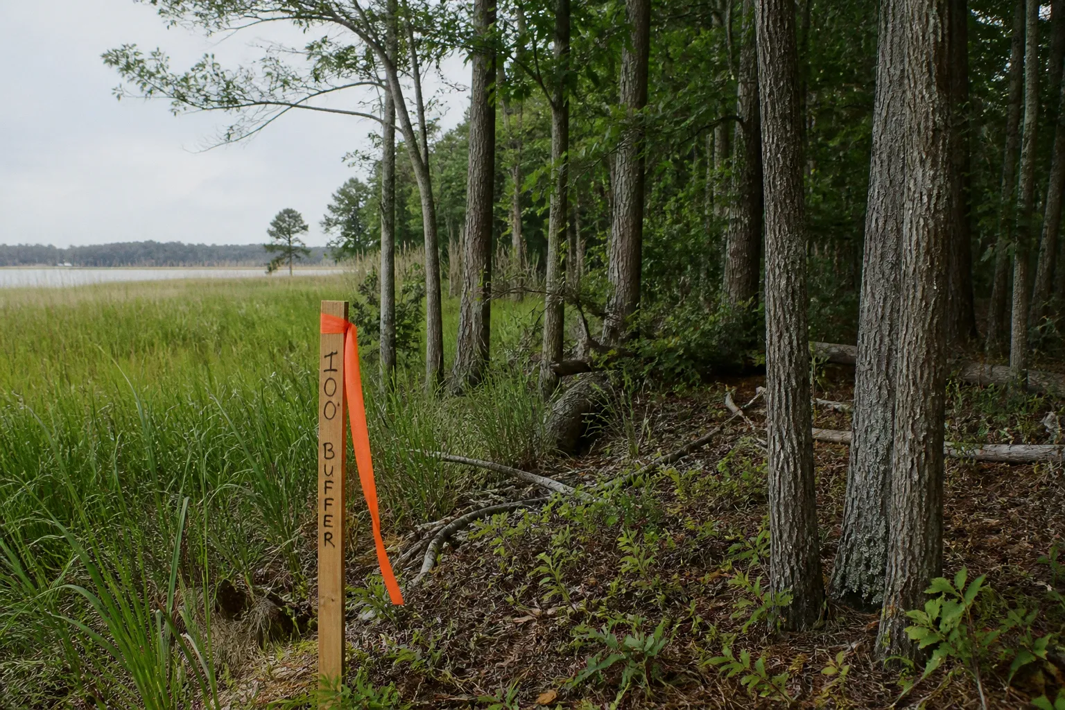
In Somerset County, however, work near tidal water, wetlands, or a tidal tributary may fall inside Maryland’s Chesapeake Bay Critical Area—and inside a regulated vegetated buffer.
That changes the order of operations. Before a saw, excavator, or grading crew arrives, you need to know whether the property lies within the Critical Area, where the buffer is located, what work is proposed, and whether a Buffer Management Plan must be approved. This Somerset County Critical Area buffer clearing checklist is designed to help you move through those questions in a practical sequence, without getting lost in planning language.
The central point is simple: do not treat buffer clearing as ordinary yard maintenance until the regulated area has been identified and the proposed work has been reviewed. Unauthorized clearing, cutting, or removal of trees, shrubs, or native understory within the buffer can constitute a civil violation.
Start with the regulatory reach: 1,000 feet, then 100 feet
The Chesapeake Bay Critical Area is broader than the shoreline itself. Maryland’s Critical Area encompasses land and water within 1,000 feet landward from the mean high water line of tidal waters, tidal wetlands, and tributary streams. That means a property does not need to touch open Chesapeake Bay water to be affected. A tidal creek, marsh edge, or tributary can bring the Critical Area into your project.
Once a property is within that larger regulatory area, the next question is whether the work falls inside the Critical Area Buffer. The buffer is a minimum 100-foot-wide strip measured landward from tidal waters, tidal wetlands, and tributary streams.
In certain locations, the buffer can extend beyond 100 feet—up to 300 feet—when site conditions create a greater risk to water quality or shoreline stability. Steep slopes, erodible soils, and sensitive environmental features are among the conditions that can lead to an expanded buffer.
What this means for your block is that a measured distance from the visible waterline may not be enough. The legal starting point is the mean high water line, not necessarily the edge of wet grass, the ordinary high-water mark you see after a storm, or the place where a seawall begins. A site may also contain wetlands or a tributary that affects the measurement.
Before planning the work, gather the basic facts:
- Is the property within Somerset County’s Chesapeake Bay Critical Area?
- Is the proposed clearing near tidal water, tidal wetlands, or a tidal tributary?
- Has the 100-foot buffer been identified on a survey, site plan, or prior approval?
- Could steep slopes, erodible soils, or sensitive areas expand the buffer?
- Does the project include tree removal, shrub removal, understory clearing, grading, construction, or shoreline stabilization?
If you cannot answer those questions confidently, that is not a reason to guess. It is the point at which you should contact the appropriate Somerset County planning and zoning authority before disturbing vegetation.
The buffer is not simply “the first 100 feet from the water.” It is a regulated area whose location depends on the shoreline, wetlands, tributaries, and the physical conditions of the site.
Put the proposed work on paper before it reaches the ground
A Buffer Management Plan is the key document for many projects involving clearing or shore erosion control within the Critical Area Buffer. The plan is not just a formality. It gives the county and other reviewing authorities a way to understand what is being removed, where the disturbance will occur, and how the work relates to the surrounding land and water.
The most useful plan begins with a clear map. Someone reviewing the proposal should be able to look at the drawing and understand:
- The property boundaries and existing structures.
- The location of tidal waters, tidal wetlands, or tributary streams.
- The measured buffer area.
- The exact disturbance area.
- Existing trees, shrubs, and native understory that may be removed.
- Access routes for equipment and workers.
- Proposed grading, shoreline work, or erosion-control features.
- Areas that will remain undisturbed.
A vague statement such as “remove dead trees near the shore” does not provide enough information for a meaningful review. The plan should identify the individual trees or groups of vegetation affected by the project. For tree removal, the submittal must clearly specify the number and sizes of trees being removed. Depending on the project, that may include species, trunk diameter, condition, and location, but the essential requirement is that the proposed removal be mapped and described rather than left to interpretation in the field.
This is where many small projects become difficult: the owner knows the work is limited, but the plan must still show the limits of that work. A contractor may see brush that appears to be in the way, while the property owner sees only a tidy-up project. The approved plan needs to make clear what can be removed and what must remain.
Build the plan around the disturbance, not the equipment
A common mistake is to describe the project by the machinery involved: “a chainsaw crew,” “a small excavator,” or “a shoreline contractor.” The review is concerned with the resulting disturbance, not whether the equipment seems modest.
Instead, describe the work in terms of land and vegetation:
1. Identify the area where soil, roots, trees, shrubs, or native groundcover may be disturbed.
2. Show how workers and equipment will reach that area.
3. Mark any temporary access or staging area.
4. Explain whether the project involves grading, fill, drainage changes, or shoreline stabilization.
5. Separate vegetation that will be removed from vegetation that will be trimmed or protected.
6. Note how disturbed ground will be stabilized after the work.
This approach makes the proposal easier to understand and gives everyone the same reference point. It also helps protect the community fabric around the site, because neighboring residents, reviewers, and contractors can see whether the work is likely to affect runoff, views, habitat, or shoreline conditions.
Include the field-flagging note
A Buffer Management Plan submittal for clearing or shore erosion control must include a note that the buffer will be physically flagged in the field during construction. That requirement matters because a line on a plan can become difficult to follow once work begins.
Field flagging turns the approved boundary into something the crew can see. It gives the contractor a practical limit and gives the property owner a way to compare the work on the ground with the approved plan. The flags should not be treated as decoration or a one-day setup step. They are part of the compliance system for the project.
Before work starts, walk the site with the contractor and confirm:
- Which trees are approved for removal.
- Which trees and native plants must remain.
- Where the buffer boundary is marked.
- Where equipment may travel.
- Where materials may be stored.
- Which areas are off-limits even if they appear overgrown.
- Who will stop the work if field conditions differ from the plan.
The person operating the equipment may not know the history of the approval. Your crew should have the plan available and should understand that “it is close enough” is not a safe interpretation of a marked buffer boundary.
Check whether the property is in a Buffer Exemption Area
Some properties are located within Buffer Exemption Areas, or BEAs. If your property falls in one of these areas, a public notice sign must be posted on the site for 15 days before work can begin.
This requirement changes your schedule. A contractor’s availability is not the same thing as legal readiness. Even if the crew can start next week, the project may need the notice period to run first. The sign should be posted in the manner required for the property and project, and the 15-day period should be completed before clearing or related work begins.
A practical planning sequence looks like this:
| Project question | Why it matters | What to document |
|---|---|---|
| Is the property within the Chesapeake Bay Critical Area? | The Critical Area rules may apply even when the property is not directly on open bay shoreline. | Property location and applicable mapping |
| Is the work inside the buffer? | Clearing inside the regulated buffer may require an approved Buffer Management Plan. | Buffer boundary and disturbance map |
| Is the site in a Buffer Exemption Area? | A public notice sign may be required for 15 days before work starts. | Posting date, location, and completion of notice period |
| What vegetation will be removed? | Tree, shrub, and native understory removal must be identified rather than estimated casually. | Tree counts, sizes, locations, and removal limits |
| Will the site be flagged? | The plan must note physical flagging during construction. | Field flagging note and contractor instructions |
| Is the work routine maintenance? | Lawn maintenance and routine pruning are treated differently from clearing or removal. | Description of the maintenance activity |
Do not assume that a BEA means the property is free from all buffer requirements. The exemption-area notice is one procedural element; it does not automatically authorize broad vegetation removal, grading, or shoreline alteration. The project still needs to be described accurately and reviewed under the applicable rules.
Know the difference between maintenance and clearing
The line between ordinary maintenance and regulated clearing is one of the most important distinctions for a homeowner or property manager.
The rules allow maintenance of existing lawns and routine pruning of trees within the Critical Area Buffer without a separate clearing permit or buffer plan. That allowance is useful, but it is narrower than many people expect.
Routine pruning generally means maintaining an existing tree in a way that does not turn into removal, major clearing, or alteration of the surrounding buffer. Lawn maintenance means caring for an established lawn, not expanding the lawn into native vegetation or removing a wooded understory to create a new open area.
The work may require review if it involves:
- Cutting down a tree, even if the tree appears unhealthy.
- Removing shrubs or native understory.
- Clearing brush to create a new yard, view corridor, driveway, or equipment route.
- Grading or changing the existing ground surface.
- Removing vegetation to prepare for construction.
- Installing or changing shoreline stabilization.
- Expanding lawn into a naturally vegetated area.
- Disturbing soil near a tidal wetland or tributary.
The condition of a tree does not, by itself, answer the approval question. Somerset County’s Critical Area rules should not be interpreted to mean that dead or dying trees may be removed without prior notification or approval from the local planning and zoning authority. If a tree is hazardous, document the condition and seek direction before removal whenever circumstances allow.
That may feel frustrating when a limb is hanging over a home or a tree has begun to lean toward a driveway. It is still better to clarify the emergency or safety situation than to let a contractor make an unrecorded decision that creates a larger compliance problem. In an urgent hazard, describe the risk clearly when contacting the authority; do not quietly convert an emergency concern into general clearing.
A quick way to describe the work
Before navigating the board or calling a county office, write a plain-language description of the project. Include:
- What vegetation is present.
- What you want removed, pruned, or left alone.
- Why the work is needed.
- How close the work is to water or wetlands.
- Whether soil will be moved.
- Whether the work is connected to construction or shoreline stabilization.
- When you hope to begin.
For example, “clear the shoreline” is too broad. A more useful description would explain that the proposal involves removing specific trees in a mapped area, pruning existing vegetation away from a structure, or installing a defined erosion-control measure. Clear language helps the reviewer direct you to the right process rather than sending you back to start over.
Prepare the site for construction-day compliance
Approval is not the end of the process. The work must still match the approved plan once people, tools, and equipment arrive.
The physical setup should make the approved limits obvious. Flagging should identify the buffer boundary and, where appropriate, the approved disturbance area. Trees approved for removal should be marked in a way that the crew can distinguish from trees to be protected. Access and staging should stay within the areas described in the plan.
A construction-day file should include:
- The approved Buffer Management Plan, if required.
- The site map showing the disturbance limits.
- The tree inventory or removal schedule.
- Documentation of any required BEA notice posting.
- Contractor contact information.
- A record of field flagging.
- Any written instructions or conditions associated with the approval.
- A method for documenting changes before they are made.
That last point deserves attention. Field conditions often look different from the plan. A tree may be more unstable than expected, an access route may be blocked, or the equipment may need to stand somewhere other than the original staging area. Those changes should not be handled by improvisation inside the buffer. Pause and ask whether the plan must be revised or whether the county needs to review the proposed change.
Give the contractor a short, direct briefing
A contractor may work on many properties in the same week, each with different rules. Do not assume that a general instruction such as “stay near the flags” is enough.
Before work begins, explain:
1. The marked buffer boundary.
2. The exact vegetation approved for removal.
3. The areas where equipment may travel or park.
4. The prohibition on expanding the work because additional brush “looks like it should go.”
5. The person who has authority to approve a change.
6. The action to take if a hazard or unexpected condition appears.
If the crew discovers additional trees that seem dangerous, or if removing one approved tree would require disturbing another area, stop and document the issue. A new decision may require county review. Keeping the project within its approved footprint is usually much easier than reconstructing what happened after an unauthorized clearing complaint.
Common mistakes that create avoidable problems
Most compliance problems do not begin with an intention to damage a shoreline or ignore the rules. They begin with a reasonable assumption that turns out to be incomplete.
Mistake 1: Measuring from the visible water’s edge
The Critical Area and buffer are tied to the mean high water line, tidal wetlands, and tributary streams. A seasonal waterline or the edge of a mowed lawn is not necessarily the regulatory starting point.
Mistake 2: Treating a small project as automatically exempt
The size of the project does not determine whether it is regulated. Removing a few trees, widening a path, or clearing a narrow view corridor can still disturb the buffer.
Mistake 3: Assuming “dead” means “no approval needed”
The rules do not create a blanket exception for dead or dying trees. Document the condition and obtain direction before removal rather than relying on a verbal assumption from a landscaper or neighbor.
Mistake 4: Letting the contractor define the work
The contractor can help execute an approved project, but the contractor should not expand the project limits in response to what appears convenient on site.
Mistake 5: Forgetting the 15-day BEA notice period
A public notice sign in a Buffer Exemption Area must be posted for 15 days before work can begin. Leaving this step until the crew is scheduled can delay the project.
Mistake 6: Submitting a plan without enough detail
A map that does not show the disturbance area, tree counts, tree sizes, access, and protected areas leaves too much room for confusion. Specificity is not needless paperwork here; it is how the project becomes understandable.
Mistake 7: Flagging the site only after equipment arrives
The buffer must be physically flagged in the field during construction, and the flagging should be in place before the crew begins relying on it. Waiting until clearing is underway invites mistakes.
A practical pre-start sequence for Somerset County property owners
If you want a simple order of operations, use this sequence before scheduling clearing or shoreline work:
1. Locate the regulatory area. Determine whether the property is within the Chesapeake Bay Critical Area and identify tidal water, wetlands, and tributaries that may affect the measurement.
2. Locate the buffer. Begin with the 100-foot minimum and determine whether site conditions may expand it toward 300 feet.
3. Describe the project. Separate pruning, lawn maintenance, tree removal, shrub removal, understory clearing, grading, construction, and shoreline stabilization.
4. Contact the local planning and zoning authority. Ask what approvals or notifications apply to the specific work and property.
5. Prepare the Buffer Management Plan if required. Map the disturbance area and identify the trees and vegetation proposed for removal.
6. Check for a Buffer Exemption Area. If the property is in a BEA, plan for the required 15-day public notice posting period.
7. Coordinate with the contractor. Make sure the crew has the approved plan, understands the limits, and knows who can authorize a change.
8. Flag the buffer in the field. Complete the physical marking before work begins and keep the markings visible throughout construction.
9. Document changes. If the field conditions differ from the plan, stop before expanding the disturbance and seek direction.
10. Restore and protect the site. Follow the approved plan for stabilization and leave the remaining buffer vegetation undisturbed.
This sequence is deliberately cautious because the cost of asking before clearing is usually lower than the cost of explaining unauthorized work afterward. Civil violations can lead to enforcement actions, and the exact monetary fine structure should not be guessed from a general project estimate. The safer focus is preventing an unapproved disturbance in the first place.
The bigger reason these rules matter
The Chesapeake Bay Critical Area Buffer is not an arbitrary line placed on a map to make ordinary property work harder. Vegetated buffers help slow runoff, hold soil in place, filter pollutants, shade waterways, and provide habitat along fragile shorelines. In a county shaped by tidal water and coastal conditions, those functions are part of the infrastructure of the landscape.
That does not mean every buffer should be treated as untouchable wilderness. Homes need access, trees sometimes need maintenance, and shorelines sometimes require protection. The point of the review process is to distinguish necessary, limited work from avoidable clearing and to make sure the proposed disturbance does not create a larger problem for the property or the water downstream.
For residents, this is also a public-participation issue. What happens on one shoreline can affect nearby drainage, erosion, views, habitat, and the community fabric around a creek or marsh. A clear plan gives neighbors and reviewers something concrete to understand. It replaces a rumor about “clearing next door” with a defined project, marked limits, and an opportunity to address concerns before damage occurs.
A good buffer plan does more than secure permission. It tells the crew, the county, and your neighbors exactly where the project ends.
Final check before anyone starts cutting
Before authorizing work, make sure you can answer yes to the following:
- Have you identified whether the property lies within the Chesapeake Bay Critical Area?
- Have you located the mean high water line, tidal wetlands, and tributary features relevant to the site?
- Has the Critical Area Buffer been mapped, including any possible expansion beyond 100 feet?
- Have you described every type of proposed disturbance?
- Have tree counts and sizes been included where trees will be removed?
- Does the Buffer Management Plan clearly show the disturbance area?
- Does the plan include the required note about physical field flagging?
- Have you confirmed whether the property is in a Buffer Exemption Area?
- If it is, has the public notice sign been posted for the full 15-day period?
- Does the contractor know which vegetation and access areas are approved?
- Is there a clear process for stopping work if conditions change?
If the answer to any of these is no, the project is not ready for the first cut. Take the extra time to clarify the buffer, complete the plan, and mark the site. That preparation is what protects both your property and the shoreline system that connects it to the rest of Somerset County.