Shoreline stabilization options for Somerset County landowners
Maryland’s Living Shorelines Protection Act of 2008 establishes the governing presumption for shoreline stabilization in tidal wetlands: nonstructural living shoreline methods must be used unless the…
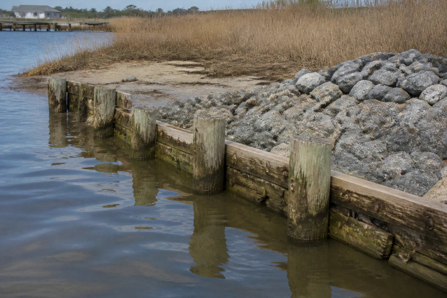
Maryland’s Living Shorelines Protection Act of 2008 establishes the governing presumption for shoreline stabilization in tidal wetlands: nonstructural living shoreline methods must be used unless the Maryland Department of the Environment grants a specific waiver. For Somerset County landowners, this means a bulkhead is not the default project. It is an exception subject to site classification, technical justification, and state approval.
The regulatory analysis begins with location. A shoreline parcel may fall within the Chesapeake Bay Critical Area, the 1,000-foot land area adjacent to tidal waters and tidal wetlands. The first 100 feet constitute the Critical Area Buffer, where clearing, grading, and buffer management are subject to additional restrictions. A project that affects the shoreline, tidal wetland, or area below the mean high water line can require state and federal review regardless of whether the proposed structure is a bulkhead, riprap revetment, sill, breakwater, or vegetated marsh edge.
The regulatory shift: living shorelines are the baseline
The practical question in the living shoreline vs. bulkhead Maryland Critical Area analysis is not simply which method controls erosion more aggressively. The first question is whether the proposed method satisfies Maryland’s statutory hierarchy.
Under the Living Shorelines Protection Act, a property owner seeking to stabilize a tidal shoreline generally must use a nonstructural approach. A living shoreline can include:
- Marsh creation and planting with suitable tidal vegetation.
- Coir logs or other biodegradable fiber structures.
- Low-profile stone sills.
- Offshore breakwaters used to reduce wave energy.
- Hybrid designs combining plantings with limited structural components.
- Other measures that preserve or restore natural shoreline functions.
The term “living shoreline” does not mean an unprotected bank with plants placed at the water’s edge. Proper design can include grading, substrate placement, wave-energy reduction, and structural elements that are subordinate to the ecological function of the shoreline. A stone sill or breakwater may be used where wave exposure makes vegetation alone inadequate. The legal and engineering analysis depends on the full design, not on the label assigned to the project.
A conventional bulkhead has a different regulatory profile. It creates a hardened vertical or near-vertical edge intended to resist direct wave attack and retain soil. That configuration can provide a defined boundary and may protect a specific upland area. It also replaces or interrupts the gradual transition between upland, intertidal zone, and tidal wetland. Maryland therefore treats structural stabilization as permissible only under specified conditions or through an MDE waiver.
In Somerset County, the shoreline treatment is determined first by statutory eligibility and site conditions, not by the owner’s preferred construction material.
The distinction matters because a landowner cannot ordinarily select a bulkhead merely because it appears more permanent, easier to maintain, or more compatible with an existing dock. The proposed work must be evaluated against Maryland’s nonstructural preference, the Critical Area requirements, and the permit standards administered by MDE.
Living shoreline versus bulkhead: the operative differences
The comparison below describes the principal regulatory and site-planning distinctions. It is not a substitute for a project-specific determination by MDE or the relevant local authorities.
| Parameter | Living shoreline or hybrid stabilization | Conventional bulkhead |
|---|---|---|
| Regulatory position | Presumptive approach for tidal shoreline protection under Maryland law | Requires an MDE waiver when the statutory preference for nonstructural methods applies |
| Physical form | Marsh, graded bank, coir logs, sill, breakwater, or a combination | Hardened vertical or near-vertical wall |
| Shoreline function | Can maintain or restore intertidal habitat and wetland transition | Primarily retains soil and resists wave forces at a fixed edge |
| Site suitability | Commonly considered where marsh creation or wave-energy reduction is feasible | Considered where structural measures are legally and technically justified |
| High-energy conditions | Can use sills, breakwaters, or other hybrid components | May resist direct wave energy but remains subject to waiver and permit requirements |
| Critical Area implications | Still subject to buffer, grading, clearing, wetland, and waterway rules | Same requirements, with additional justification for structural stabilization |
| Work below mean high water | Requires state authorization and may require federal review | Requires state authorization and may require federal review |
| Long-term assessment | Vegetation establishment, sediment behavior, scour, and structural performance must be monitored | Wall integrity, toe scour, tiebacks, settlement, and adjacent shoreline effects require monitoring |
| Cost comparison | Cannot be reduced to a universal per-linear-foot figure; design varies by depth, exposure, materials, and contractor | Same limitation; site conditions and structural design control the bid price |
The table also explains why simplistic comparisons such as “riprap versus living shoreline cost” are unreliable. Riprap is not a single standardized product with a fixed installation price. Its cost and regulatory treatment depend on stone size, bank geometry, access, water depth, substrate, equipment requirements, and whether the design is a revetment, sill, toe protection, or component of a larger hybrid system. The same applies to living shoreline work. Marsh planting on a low-energy bank is not equivalent to a project requiring extensive grading, coir logs, stone sills, and wave attenuation.
Maryland’s regulatory system therefore does not operate as a simple price comparison between plantings and hardened structures. It evaluates whether the selected stabilization method is technically suitable and legally authorized for the particular shoreline.
Critical Area Buffer requirements control the upland portion
The Chesapeake Bay Critical Area Law, enacted in 1984, establishes a 1,000-foot Critical Area adjacent to tidal waters and tidal wetlands. Within that area, the first 100 feet form the Critical Area Buffer. This buffer is a central constraint for Somerset County shoreline projects.
A stabilization project may involve more than work in the water. Access routes, construction staging, grading, vegetation removal, drainage changes, and alterations to the bank can affect the buffer. A landowner evaluating shoreline erosion control options should separate the project into at least two regulatory zones:
1. The tidal and intertidal work area.
This includes the shoreline, tidal wetland, and any construction below the mean high water line. It is governed by tidal wetlands and waterway construction requirements.
2. The upland and buffer area.
This includes the bank, access path, staging area, grading footprint, and vegetation within the Critical Area. Clearing or grading in this zone can trigger additional review and mitigation requirements.
The 100-foot buffer is measured from tidal waters and tidal wetlands under the applicable Critical Area framework. Its boundary should not be assumed from a parcel map, a driveway, or the visible edge of a bank. The mapped shoreline, tidal wetland extent, and site conditions control the analysis.
For a Somerset County property owner, the initial site file should therefore identify:
- The parcel boundary and recorded easements.
- The location of tidal waters and tidal wetlands.
- The 1,000-foot Critical Area boundary.
- The 100-foot Critical Area Buffer.
- Existing development and impervious surfaces.
- Existing vegetation and any regulated buffer disturbance.
- The mean high water line.
- Existing docks, piers, bulkheads, riprap, drainage outlets, and access routes.
- Any recorded restrictions affecting construction or shoreline access.
This is not administrative excess. It prevents a common failure in shoreline planning: treating the project as a narrow line along the water while ignoring the land disturbance needed to construct it.
Setback requirements and easement delineations
A shoreline stabilization design can also be affected by setback requirements and easement delineations. The exact controls depend on the applicable local zoning framework, recorded property instruments, and the project’s relationship to public or private infrastructure.
An owner may possess the upland parcel but lack unrestricted authority to install work across an easement, shared access corridor, drainage facility, or right-of-way. A stabilization feature may also extend beyond the practical control of one owner through its interaction with an adjacent parcel or common shoreline.
The review should address:
- Whether the construction footprint remains within the owner’s legal interest.
- Whether access equipment must cross another parcel.
- Whether a drainage or utility easement occupies the proposed staging area.
- Whether a shared shoreline requires coordinated design.
- Whether the structure could redirect erosion toward an adjoining property.
- Whether existing shoreline work was authorized and can be incorporated into the new design.
A permit does not resolve every private property issue. Statutory compliance and property authority are separate questions.
When a structural bulkhead waiver is legally permissible
The Maryland Department of the Environment can issue a Living Shoreline Waiver for structural stabilization where the statutory criteria are met. The owner must establish more than a preference for a bulkhead. The site must be officially mapped as suitable for structural measures or demonstrated to be unsuitable for a living shoreline because of specific physical conditions.
Relevant conditions include:
- Severe wave energy.
- Excessive erosion.
- Extreme water depth.
- Soft bottom substrate.
- Other site characteristics that prevent a living shoreline from functioning as designed.
These conditions must be tied to the actual shoreline, not asserted in general terms. A property located on a broad sound, exposed channel, or fetch with significant wave action is not automatically exempt. Conversely, the existence of wave energy does not mean living shoreline methods are prohibited. Hybrid designs using stone sills or breakwaters are intended to address conditions in which vegetation alone may not provide sufficient stabilization.
The waiver process should therefore be approached as a technical demonstration. A complete analysis may need to document:
1. Shoreline exposure.
The design professional should characterize the site’s exposure to wind-generated waves and identify whether the proposed treatment can reduce that energy without creating new erosion problems.
2. Bank and substrate conditions.
Soil composition, bottom softness, bank stability, and existing scour influence whether marsh plantings, fiber structures, or a hybrid design can establish successfully.
3. Water depth and profile.
Extreme depth or a steep underwater profile may limit the feasibility of a conventional living shoreline. The profile must be measured rather than inferred from visual inspection.
4. Erosion mechanism.
The source may be wave attack, boat wake, storm flow, drainage discharge, bank failure, or a combination. A wall designed for one mechanism may not correct another.
5. Adjacent shoreline effects.
A hardened edge can reflect wave energy and alter sediment movement. The design must account for potential scour at the structure’s toe and increased exposure at the neighboring shoreline.
6. Alternative designs.
The waiver record should explain why a living shoreline or hybrid method is not technically suitable, rather than merely listing the preferred structural option.
The legal distinction is precise. A bulkhead may be engineered to resist erosion and still fail the statutory test if the owner has not shown that a nonstructural or hybrid method is unsuitable or that the site is mapped for structural measures.
A waiver is not a construction license. It resolves one statutory issue; tidal wetlands, waterway, Critical Area, local zoning, and federal requirements remain separate.
Somerset County shoreline permits and the state review framework
Work below the mean high water line is regulated through Maryland’s wetlands and waterways framework. The principal state regulations identified for these projects are:
- COMAR 26.24, governing tidal wetlands.
- COMAR 26.17, governing waterway construction.
The Maryland Department of the Environment’s Wetlands and Waterways Program administers the relevant state review. Federal review may also be required through the U.S. Army Corps of Engineers Baltimore District. The applicable review depends on the work’s location, design, waterbody, construction method, and effects on tidal wetlands or navigable waters.
For practical purposes, a Somerset County shoreline project should be assembled as a coordinated application rather than as separate informal requests. The submission should describe:
- Existing shoreline conditions.
- The erosion problem and its documented cause.
- The proposed alignment and cross-section.
- Materials and construction methods.
- Work limits relative to mean high water.
- Effects on tidal wetlands and submerged lands.
- Vegetation removal and replacement.
- Access and staging.
- Temporary construction impacts.
- Proposed erosion and sediment controls.
- Relationship to neighboring properties and existing structures.
- The basis for selecting a living shoreline, hybrid treatment, riprap, or bulkhead.
- Any requested Living Shoreline Waiver.
The owner should not assume that a local zoning approval authorizes work in tidal wetlands. Local planning and zoning review may address land use, setbacks, site access, buffer disturbance, or related development controls. State and federal agencies regulate the water-dependent work under their own statutory authorities.
Typical permitting errors
Several errors repeatedly create avoidable delays or redesign obligations.
Treating the shoreline as a property-line improvement.
The waterward portion of the project may fall under state and federal jurisdiction. The parcel boundary does not establish the permit boundary.
Submitting a bulkhead design without a waiver strategy.
Where the Living Shorelines Protection Act applies, the application must address the statutory preference for nonstructural methods and the basis for structural eligibility.
Using “living shoreline” as a label without ecological content.
A planted strip placed in front of a failing bank is not necessarily an adequate stabilization design. The project must address wave energy, bank geometry, substrate, tidal inundation, and establishment conditions.
Ignoring hybrid alternatives.
The choice is not always vegetation or wall. Coir logs, sills, breakwaters, and marsh plantings can be combined where the site requires wave attenuation and habitat restoration.
Separating construction access from the project design.
Equipment access through the Critical Area Buffer can create the principal disturbance even when the shoreline treatment itself is compliant.
Failing to evaluate adjacent erosion.
A structure that protects one frontage can change flow, wave reflection, or sediment transport along the next frontage. The design record should address these effects.
State resources supporting Somerset County coastal resilience
Maryland has directed funding toward living shoreline projects on the Eastern Shore. In June 2024, the Maryland Department of Natural Resources awarded more than $4.5 million through the Roots for Resilience program for Eastern Shore living shoreline projects. Four targeted locations were identified in Somerset County: Pocomoke Sound, Smith Island, Deal Island, and Franks Island.
These projects do not eliminate the need for private permitting. They do, however, establish the regional policy context. Somerset County is not being treated as an isolated set of erosion complaints. Public investment is supporting nature-based shoreline stabilization in locations exposed to coastal erosion, storm events, and sea-level-rise impacts.
The distinction between public projects and private parcels remains important:
- A public resilience project may use a larger, coordinated shoreline segment.
- A private property may require a site-specific design and separate permit review.
- Grant-funded work may have its own eligibility, ownership, maintenance, and monitoring conditions.
- A nearby demonstration project does not automatically establish that the same treatment is suitable for another parcel.
- The presence of a living shoreline at one location does not waive the need for a technical site assessment elsewhere.
For private landowners, the relevant benefit is technical and institutional as much as financial. Regional projects can improve local knowledge about plant selection, sill design, wave exposure, construction access, and maintenance. They may also identify shoreline segments where coordinated stabilization is more effective than isolated improvements.
Somerset County’s coastal geography makes this coordination material. Pocomoke Sound, Smith Island, Deal Island, and Franks Island do not present identical wave climates, substrate conditions, access constraints, or shoreline profiles. A countywide policy preference for living shorelines must still be implemented through parcel-level design.
Assessing the site through the Maryland Shoreline Stabilization Mapper
The Maryland Shoreline Stabilization Mapper, developed with the Virginia Institute of Marine Science, provides site-specific recommendations. It categorizes shoreline areas into broad treatment groups:
- Living shoreline.
- Structural measures.
- Special considerations.
The mapper should be used as an initial screening tool, not as a permit determination. Its value is in organizing the first stage of due diligence before an owner commissions a detailed design.
A disciplined review sequence is as follows.
1. Locate the parcel and shoreline segment
The owner should identify the exact frontage rather than evaluating the property by municipality or waterbody name alone. A single parcel can contain different conditions along its shoreline.
2. Review the mapped recommendation
The mapper’s category can indicate whether the location is generally associated with living shoreline methods, structural measures, or additional site-specific complications. The result should be preserved with the date of review because mapping products and site conditions can change.
3. Compare the map with field conditions
The map does not replace field verification. The owner must compare the recommendation against:
- Existing bank failure.
- Visible toe scour.
- Marsh presence.
- Wave exposure.
- Water depth.
- Bottom substrate.
- Existing structures.
- Drainage outlets.
- Construction access.
- Neighboring shoreline treatments.
If the mapped category and observed conditions differ, the discrepancy should be addressed in the engineering and permitting record.
4. Determine the Critical Area and buffer relationship
The owner should map the 1,000-foot Critical Area and identify the 100-foot Critical Area Buffer. The proposed construction access, grading, vegetation removal, and staging footprint should be included. A design that is compliant at the waterline can still require revision because of upland buffer impacts.
5. Select a design category
The initial options usually include:
- A predominantly vegetated living shoreline.
- A living shoreline with coir logs or similar biodegradable components.
- A hybrid shoreline with marsh plantings and a stone sill.
- A hybrid shoreline using a breakwater to reduce wave energy.
- Riprap or another structural treatment where authorized.
- A bulkhead where the site satisfies waiver requirements and all permits are obtained.
The choice should follow the site evidence. It should not be reversed merely because a particular material appears more familiar to a contractor.
6. Prepare the regulatory record
The final design package should explain the relationship among the site conditions, the selected treatment, the Critical Area requirements, the MDE application, and any federal review. The record must be internally consistent. A plan describing a living shoreline in one section and a bulkhead in another creates a substantive—not merely clerical—problem.
Riprap, sills, breakwaters, and bulkheads are not interchangeable
The phrase “structural stabilization” covers different physical systems. A bulkhead, riprap revetment, stone sill, and offshore breakwater do not have the same shoreline geometry or ecological effect.
A bulkhead places a hardened wall at the bank edge. It may retain upland soil and create a clear vertical boundary. Its design must address lateral earth pressure, settlement, toe scour, tiebacks or anchoring, and the effect of reflected wave energy.
Riprap places stone along a slope or bank to absorb and dissipate wave energy. It can reduce direct erosion but may require substantial grading and can occupy the intertidal zone. Its suitability depends on bank angle, stone sizing, underlying material, access, and the treatment of the toe.
A stone sill is generally a lower-profile feature designed to reduce wave energy while allowing a marsh or vegetated shoreline to develop landward of or behind it. The sill does not function as a conventional vertical wall.
An offshore breakwater is positioned waterward of the bank to reduce incoming wave energy before it reaches the shoreline. It may support marsh establishment but introduces its own questions regarding alignment, gaps, water exchange, navigation, and sediment movement.
These distinctions affect both permitting and design. Calling a project “riprap” does not avoid the Living Shorelines Protection Act. Calling a project “hybrid” does not automatically establish compliance. The agencies will evaluate the actual footprint, materials, configuration, and effects.
A legally defensible decision sequence
A Somerset County landowner can reduce avoidable conflict by using the following order of operations:
1. Establish the regulatory location.
Confirm whether the parcel lies within the Chesapeake Bay Critical Area and identify the 100-foot Critical Area Buffer, tidal wetlands, and the mean high water line.
2. Document the erosion mechanism.
Record bank geometry, visible scour, marsh loss, drainage, wave exposure, and any storm-related damage. The design must respond to the mechanism causing the erosion.
3. Run the Maryland Shoreline Stabilization Mapper review.
Preserve the relevant site category and compare it with observed conditions.
4. Evaluate living shoreline and hybrid designs first.
Consider marsh plantings, coir logs, sills, breakwaters, and combinations that reduce wave energy while maintaining shoreline function.
5. Determine whether structural stabilization is legally supportable.
If a bulkhead or other hardened measure is proposed, identify the applicable waiver basis. Severe wave energy, excessive erosion, extreme water depth, or soft bottom substrate must be tied to documented site conditions.
6. Map all disturbance.
Include upland grading, clearing, access, staging, temporary work areas, and material delivery. The regulatory footprint extends beyond the visible shoreline structure.
7. Coordinate state and federal review.
Address COMAR 26.24 for tidal wetlands, COMAR 26.17 for waterway construction, and any review by the U.S. Army Corps of Engineers Baltimore District.
8. Resolve property and easement issues.
Confirm authority over the construction area and access route. A permit does not cure an easement conflict or authorize encroachment onto another parcel.
9. Design for adjacent shorelines.
Evaluate toe scour, redirected erosion, wave reflection, and sediment movement at the property boundaries.
10. Submit a consistent technical record.
The plans, narrative, waiver request, site photographs, mapping, and engineering analysis must describe the same project.
Final determination
For Somerset County property owners, the living shoreline vs. bulkhead Maryland Critical Area comparison has a defined legal starting point. Maryland law prioritizes nonstructural living shoreline methods for tidal shoreline protection. A bulkhead or other hardened structure requires a site-specific justification and, where applicable, an MDE Living Shoreline Waiver.
The 1,000-foot Critical Area and its 100-foot Buffer control more than the water’s edge. Grading, clearing, access, drainage, and construction staging can determine whether the project is compliant. Work below the mean high water line must be analyzed under COMAR 26.24 and COMAR 26.17, with federal review considered through the U.S. Army Corps of Engineers Baltimore District.
Living shorelines, riprap, sills, breakwaters, and bulkheads are distinct design systems. None should be selected through a generic cost comparison or by material preference alone. The defensible process is location-specific: map the regulatory boundaries, document the erosion mechanism, evaluate nonstructural and hybrid alternatives, establish any waiver basis, and submit a coordinated permit record.
In Somerset County, statutory compliance is inseparable from shoreline geometry. The legally viable stabilization method is the one that matches both.